
Alkane Resources Limited
29.7.2026 04:08:11 CEST | Globenewswire | Press release
Alkane Significantly Increases Storheden Mineral Resource and Provides Exploration Update
Alkane Significantly Increases Storheden Mineral Resource and Provides Exploration Update
PERTH, Australia, July 28, 2026 (GLOBE NEWSWIRE) -- Alkane Resources Limited (ASX: ALK; TSX: ALK; OTCQX: ALKRY) ("Alkane" or "the Company") is pleased to announce the latest exploration results and an updated Mineral Resource for the Storheden Deposit at its Björkdal Operation in northern Sweden.
Program Summary
- The Storheden Deposit is located approximately 700 m north of the Björkdal mine, with recent drilling intercepting gold-bearing Quartz veins along 2.7 km strike length and to a depth of 464 m. The mineralisation remains open in all directions.
- 16 extensional diamond drill holes were completed at Storheden during January-March 2026, intercepting high-grade mineralisation within target zones defined through previous drilling campaigns.
- The recent drilling has contributed to an improved understanding of the lithostructural controls on gold-bearing Quartz veins, defining units that form targets for follow-up drilling.
- New modeling at Storheden including drilling over 2025 and 2026 has improved confidence, with inclusion of Indicated Resources, higher grade and significantly higher contained gold ounces.
- Indicated Resources 1.07 Mt grading 2.51 g/t Au (87 koz) and;
- Inferred Resources 1.85 Mt grading 2.11 g/t Au (125 koz)
- Details to follow in the annual NI43-101 Björkdal Technical document in September 2026
- New modeling at Storheden including drilling over 2025 and 2026 has improved confidence, with inclusion of Indicated Resources, higher grade and significantly higher contained gold ounces.
Assay Highlights
- From the Storheden Resource Growth campaign
- 36.1 g/t gold over 0.5 m (ETW 0.35 m) in SH26-004
- 50.9 g/t gold over 0.95 m (ETW 0.82 m) and
- 39.2 g/t gold over 0.6 m (ETW 0.46 m) in SH26-010
- 107.0 g/t gold over 0.4 m (ETW 0.35 m) in SH26-011
- 27.4 g/t gold over 0.70 m (ETW 0.49 m) in SH26-012
Note: ETW refers to the Estimated True Width of the intercept. A full list of significant Storheden Intercepts can be found in Appendix 1.
Alkane Managing Director & CEO, Nic Earner, said:
“Storheden represents an exciting new growth prospect at Björkdal. The positive drilling results of this latest campaign begin to demonstrate the scale of the deposit, with the extent and depth continuity still unknown and open. Additionally, portions of the Mineral Resource have now been drilled to a density sufficient to estimate Indicated Resource. Encouraged by continued positive results coupled with the potential Storheden provides, Alkane will continue to define the extents of the deposit and lift confidence in resources alongside the commencement of mine development to Storheden and the progression of permitting requirements for extraction.”
Björkdal Mine
Alkane Resources Ltd 100%
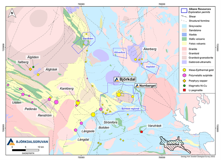
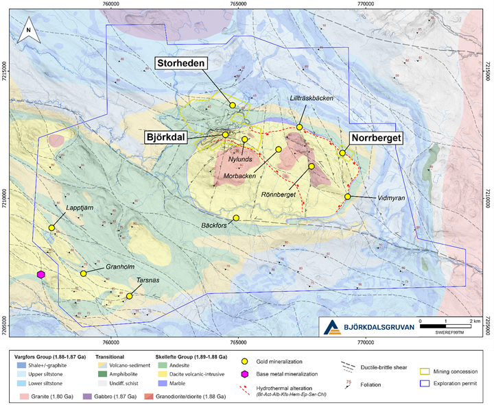
The Björkdal Gold Mine is located on the eastern margin of the Early Paleoproterozoic Skellefte Belt in northern Sweden, which hosts numerous base and precious metal deposits, including polymetallic massive sulphide (Zn-Cu-Pb-Au-Ag), meso- and epithermal gold, porphyry Cu, and magmatic Ni-Cu (figure 1). The mine is located approximately 30 km northwest of Skellefteå and 750 km north of Stockholm.
Figure 1: Regional geological map of the eastern Skellefte district, showing major deposits and merged outlines of exploration permits held by Alkane Resources.
The deposit was discovered in 1983 by Terra Mining AB through a glacial till sampling program that identified anomalous gold values. Follow-up exploration led to the discovery of gold mineralisation in bedrock in 1985, with open pit mining commencing in July 1988. Underground mining started in 2008, while the open pit remained in operation until it was paused in 2019. Since production began in 1988, the Björkdal Mine has produced approximately 1.69 million ounces of gold.
Deposit Geology
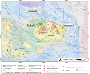
The Björkdal and Storheden Deposits are hosted in volcanics and associated intrusives belonging to the regional Skellefte Group and located within a fold-and-thrust system that developed along the northwestern margin of the Björkdal dome (Figure 2). Free-milling gold occurs in association with steep to subvertical Quartz veins that formed in proximity to major stratigraphic contacts, where the rheological contrast between volcanic, intrusive and sedimentary units favoured multi-phase deformation, alteration and fluid flow across the ductile-brittle transition. The mineralisation is classified as Mesothermal orogenic gold.1
Figure 2: Geology of the Björkdal dome and surroundings, showing outline of currently held exploration permits and mining concessions at the Björkdal, Storheden and Norrberget deposits.
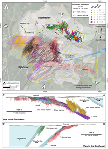
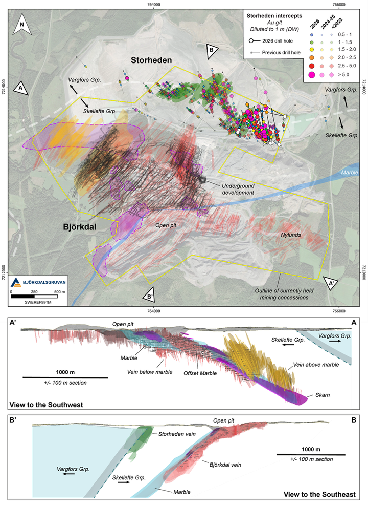
Gold-bearing Quartz veins in the Björkdal deposit are localised along a sheared, partially offset and skarn-altered marble horizon, which hosts pockets of irregular but high-grade Quartz veins (figure 3). The marble acted as a major detachment between moderately W- to NW-dipping thrust-duplex systems that developed within its respective hanging and footwall, in conjunction with folding and antiformal doming. Mineralised Quartz veins in the Storheden Deposit are similarly located along steeply dipping shears that developed within the Upper Skellefte Group, along the contact with sediment in the overlying Vargfors Group. Reverse shears acted as conduits for ore-bearing fluids and facilitated fracturing in surrounding rocks. Major structures and contacts subdivide the deposits into blocks with distinct styles of veining, with high-grade mineralisation favoured by structural complexity.
Figure 3: Plan overview and sections of Björkdal-Storheden, showing Storheden drill intercepts in relation to modelled mineralised veins and major contacts. A close-up of Storheden is provided in figure 4.
In both Björkdal and Storheden, the principal set of mineralised Quartz veins strike NE-SW, with veins ranging from centimetre- to metre-scale. Visible gold is often found along reactivated vein margins and is closely associated with Bismuth-Tellurides and Scheelite. Pyrite and Pyrrhotite constitute common sulphides, which occur with lesser Chalcopyrite, Bornite, Molybdenite, Sphalerite and Galena. Arsenopyrite occurs in a subset of veins at Storheden, while rare Magnetite veinlets are present below the marble in the Björkdal deposit.
Two main phases of hydrothermal activity have been proposed within the Björkdal dome:
- Early widespread hydrothermal alteration (Silica-Biotite-Albite-Actinolite-K-feldspar-Hematite-Epidote-Sericite) in the interior of the dome has been compared to a porphyry-style or intrusion-related system (figure 2). Although no significant Cu-Au-Mo mineralisation has so far been identified within the dome, this alteration could be associated with early porphyry Cu±Au±Mo and intrusion-related gold deposits elsewhere in the district, such as Tallberg and Älgträsk located 30 km west of Björkdal (figure 1). The alteration event may have preceded the deposition of the marble, which is interpreted to mark an erosional unconformity.
- Late hydrothermal activity was linked to orogenic-style gold mineralisation, where competence contrasts enhanced by early alteration likely influenced later structures. At this stage, the marble acted as an impermeable cap for hydrothermal fluids and provided a favourable environment for gold precipitation. The sheared offset of the marble in the Björkdal deposit (figure 2) provided a pathway for mineralised fluids across the stratigraphy, linking mineralisation in Storheden with the Björkdal deposit and several smaller gold prospects extending towards the SE.
Storheden
Mineralisation at Storheden was discovered by Terra Mining AB, prior to the establishment of the tailings dam. Subsequent exploration efforts have been hampered by a lack of understanding of the mineralisation and the limitations imposed by the expanding tailings.
Starting in 2023, a renewed focus was placed on Storheden, including a re-evaluation of the geology based on the structural controls established within the Björkdal deposit. Three diamond drilling campaigns were conducted from 2023 to 2025, leading to the merger of Mandalay Resources with Alkane Resources. These campaigns extended the known footprint of the Storheden Deposit to more than 2.7 km strike length and a depth of 464m, resulting in an initial Inferred Mineral Resource of 1.77 Mt grading 1.74 g/t Au (99 koz Au).2
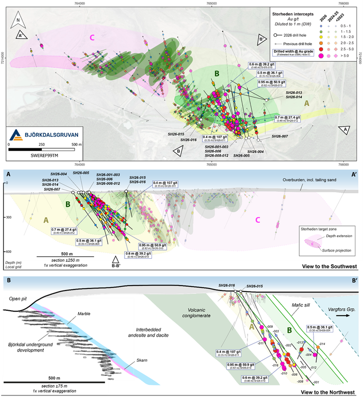
Auriferous Quartz veins at Storheden are distributed across several stratigraphic intervals in the Upper Skellefte Group and its transitional contact with the overlying Vargfors Group, with the style and geometry of veining influenced by the nature of the host rock (figure 3-4). Within the Skellefte Group, steeply SE-dipping mineralised veins occur preferentially within sheared and altered andesitic units, which dip moderately (40-50°) to the north. Higher up in the stratigraphy, closer to the Vargfors Group, Quartz veins appear to form larger panels, dipping steeply (70°) towards the W-NW. The change in geometry is similar to the difference observed in the Björkdal deposit between veins located below and above the marble (figure 3). The similarities between the two deposits could indicate that there is a degree of structural repetition, in which the distribution of mineralised zones in Björkdal could help inform on mineralisation in Storheden.
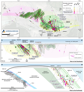
Veining in Storheden is further influenced by the presence of massive mafic sills, which constitute rheological anomalies within the stratigraphy (figure 4). They are interpreted to act as focal points for deformation and fluid flow, often defining the hanging and footwall of mineralised zones. These units provide useful exploration targets for future drill testing.
Figure 4: Detailed plan view, long section and cross section of Storheden, showing 2026 intercepts in relation to previous drilling, modelled wireframes and target zones.
To date, no direct connectivity has been established between the Storheden and Björkdal deposits. However, their comparable style of mineralisation indicates that that they share a common source of ore-bearing fluids at depth, likely at the base of the fold-and-thrust system hosting both deposits (figure 3). Mineralised veining in Björkdal currently extends to almost double the depth that has been tested at Storheden, further indicating that it has significant down-dip potential. Storheden also remains open to the west, where there is a possibility for the mineralised system to connect with veining above marble in the Björkdal deposit, although drilling in this area is challenging due to thick overburden and the location of the tailings.
Drilling Results
Following the last update on the Storheden Deposit3, 16 extensional diamond drill holes have been completed between January and March 2026, totalling 7,965 m (figure 3). Drilling was focused on Target Zones A and B, defined during previous drilling campaigns. These are situated close to existing mine infrastructure, both surface and underground, at a horizontal distance of 700-800 m.
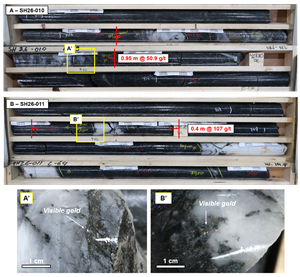
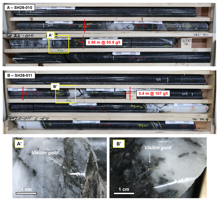
A total of 14 holes were drilled in Target Zone A, including SH26-001 to SH26-012, and SH26-015 to SH26-016, which successfully extended high-grade mineralisation 450 m along strike to the east (figure 4). Mineralisation in this zone remains open to the west and east, as well as at depth. These drill holes intercepted mineralized Quartz veins with an encouraging consistency in frequency, strike and dip. Visible gold occurred in multiple veins, returning high-grade intercepts including 50.9 g/t Au over 0.95 m from 406.2 m in drill hole SH26-010 and 107 g/t over 0.40 m from 293.3-293.7 m in drill hole SH26-011 (figure 5).
Figure 5: Core tray photograph of high-grade veining in SH26-010 (406.2-407.15 m), and in SH26-011 (293.3-293.7 m).
There remains a gap between wireframes modelled from the 2026 campaign and previous drilling, due to a lack of accessible drill sites to test this area. However, veining is expected to be continuous across this gap, and new surface sites are being prepared to allow this space to be targeted with follow-up drilling.
In the 2026 campaign, two additional drill holes (SH26-013 and SH26-014) also depth-tested Target Zone B, with hole SH26-013 intercepting multiple veins with visible gold (figure 4). Current drilling is insufficient to define a resource in this zone, but the intercepts demonstrate its potential to host further mineralisation and will be targeted with follow-up drilling.
Updated Mineral Resource
The Storheden Mineral Resource estimate has been updated to incorporate 28 additional diamond drill holes (14,061 m drilled) completed during the 2025 exploration program and the first months of 2026 (figure 6). The updated geological model comprises 74 mineralised wireframes, with all previously interpreted mineralised domains reviewed and refined where required to incorporate the new drilling information. The revised interpretation provides improved confidence in the geometry and continuity of the mineralised zones and forms the basis of the updated Mineral Resource estimate.
The updated Mineral Resource includes Indicated Resources of 1,075 kt at 2.51 g/t Au (87 koz Au) and Inferred Resources of 1,846 kt at 2.11 g/t Au (125 koz Au). This marks an increase of approximately 26% in Inferred contained gold from the previous Inferred Resource (1.77 Mt grading 1.74 g/t Au for 99 koz4) as well as the creation of Indicated Resources totalling 87 koz of contained gold. The increase in Mineral Resources reflects the successful conversion of recent drilling results into the geological and resource models, resulting in an expansion of the interpreted mineralised domains together with improved definition of existing mineralisation.
Mineral Resources at Storheden, as of 7 June 2026
| Category | Inventory (kt) | Gold grade (g/t) | Contained Gold (koz) |
| Indicated | 1,075 | 2.51 | 87 |
| Inferred | 1,846 | 2.11 | 125 |
Notes:
- Mineral Resources are estimated using drill hole and sample data as of 7 June 2026.
- Mineral Resources are classified and reported in accordance with the guidelines of the JORC Code (2012); the classifications are consistent with Canadian Institute of Mining, Metallurgy and Petroleum (CIM) Definition Standards for Mineral Resources and Mineral Reserves (CIM (2014) definitions).
- Mineral Resources are estimated using an average gold price of US$3,100/oz and an exchange rate of 10.0 SEK/US$.
- High gold assays for the underground mine were capped at 60 g/t Au for the first search pass and 40 g/t Au for subsequent passes.
- Interpolation was by inverse distance cubed (ID3) utilising diamond drill, reverse circulation, and chip channel samples.
- Underground Mineral Resources are estimated at a cut-off grade of 0.65 g/t Au.
- A nominal 2.5 m minimum mining width was used to interpret veins.
- Mineral Resources that are not Mineral Reserves do not have demonstrated economic viability.
- Numbers may not add due to rounding.
- Competent Person for the Storheden Mineral Resource estimates is Reno Pressacco, M.Sc.(A)., P.Geo., FGC, Associate Principal Geologist with SLR, who is a Competent Person as defined by JORC (2012).
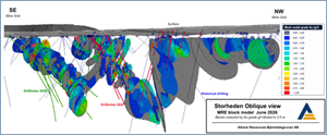
Figure 6: Perspective view of the Storheden Block Model looking to the NE.
Future Plans
Additional surface drilling is planned at Storheden with the aim to grow its resource base and delineate the limits of the system, with an initial 10,000 meters planned for FY2027. This drilling will also inform on the design of a planned underground exploration drive for which development is scheduled to commence in September 2026. The drive will provide a platform for depth-testing the Storheden Deposit as well as additional infill drilling, while also being designed to support potential future production.
Regional exploration is focused on delineating satellite deposits that can complement the Björkdal mine. Historically, exploration has focused on the marble horizon that rims the Björkdal dome and is closely associated with the Björkdal and Norrberget deposits. However, the Storheden Deposit demonstrates the potential for economic mineralisation outside of this stratigraphic interval.
This document has been authorised for release to the market by Nic Earner, Managing Director and CEO.
ABOUT ALKANE ‐ www.alkres.com ‐ ASX:ALK | TSX: ALK | OTCQX: ALKRY
Alkane (ASX:ALK; TSX:ALK; OTCQX:ALKRY) is an Australia-based gold and antimony producer with a portfolio of three operating mines across Australia and Sweden. The Company has a strong balance sheet and is positioned for further growth.
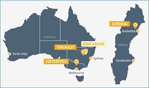
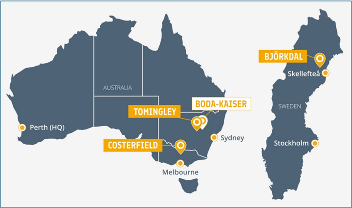
Alkane’s wholly owned producing assets are the Tomingley open pit and underground gold mine southwest of Dubbo in Central West New South Wales, the Costerfield gold and antimony underground mining operation northeast of Heathcote in Central Victoria, and the Björkdal underground gold mine northwest of Skellefteå in Sweden (approximately 750 km north of Stockholm). Ongoing near-mine regional exploration continues to grow resources at all three operations.
Alkane also owns the very large gold-copper porphyry Boda-Kaiser Project in Central West New South Wales and has outlined an economic development pathway in a Scoping Study. The Company has ongoing exploration within the surrounding Northern Molong Porphyry Project and is confident of further enhancing eastern Australia’s reputation as a significant gold, copper and antimony production region.
Competent Persons Statement
Certain information in this announcement relating to Exploration Results has been previously released to the ASX. Alkane confirms that it is not aware of any new information or data that materially affects the information included in those market announcements and that all material assumptions and technical parameters underpinning the estimates and Exploration Results in those announcements continue to apply and have not materially changed.
The information in this report that relates to the Storheden Exploration Results is based on, and fairly represents, information compiled and verified by Mr Chris Davis. Mr Davis is a Chartered Professional (Geology) of the Australasian Institute of Mining and Metallurgy (MAusIMM CP(Geo)), and a Member of the Australian Institute of Geoscientists (MAIG).
Mr Davis has sufficient experience that is relevant to the style of mineralisation and type of deposit under consideration and to the activity being undertaken to qualify as a Competent Person as defined in the 2012 Edition of the “Australian Code for Reporting of Exploration Results, Mineral Resources, and Ore Reserves” (JORC Code).
For the purposes of National Instrument 43-101 – Standards of Disclosure for Mineral Projects (‘NI 43-101’), the scientific and technical information contained in this announcement relating to the Storheden Results has been prepared under the supervision of, and approved by, Mr Chris Davis, who is a “qualified person” as defined in NI 43-101. Mr Davis is employed by Alkane as Chief Geologist and, as an employee of Alkane, is not considered independent of Alkane within the meaning of NI 43-101.
Mr Davis consents to the inclusion in this report of the matters based on his information in the form and context in which they appear.
The information in this report that relates to the Storheden Mineral Resource is based on, and fairly represents, information compiled and verified by Mr Reno Pressacco, P.Geo., who is a member of the Association of Professional Geoscientists of Ontario.
Mr Pressacco has sufficient experience that is relevant to the style of mineralisation and type of deposit under consideration and to the activity being undertaken to qualify as a Competent Person as defined in the 2012 Edition of the “Australian Code for Reporting of Exploration Results, Mineral Resources, and Ore Reserves” (JORC Code).
For the purposes of National Instrument 43-101 – Standards of Disclosure for Mineral Projects (‘NI 43-101’), the scientific and technical information contained in this announcement relating to the Storheden Mineral Resource has been prepared under the supervision of, and approved by, Mr Reno Pressacco, who is a “qualified person” as defined in NI 43-101. Mr Pressacco is employed by SLR Consulting (Canada) and is considered independent of Alkane within the meaning of NI 43-101.
Mr Pressacco consents to the inclusion in this report of the matters based on his information in the form and context in which they appear.
Cautionary Note Regarding Forward-Looking Information and Statements
This announcement contains certain forward-looking information and forward-looking statements within the meaning of applicable securities legislation and may include future-oriented financial information or financial outlook information (collectively Forward-Looking Information). Actual results and outcomes may vary materially from the amounts set out in any Forward-Looking Information. As well, Forward-Looking Information may relate to: future outlook and anticipated events; expectations regarding exploration potential; production capabilities and future financial or operating performance, including AISC, investment returns, margins and share price performance; production and cost guidance and the timing thereof; issuing updated resources and reserves estimate and the timing thereof; the potential of Alkane to meet industry targets, public profile and expectations; and future plans, projections, objectives, estimates and forecasts and the timing related thereto.
Forward-Looking Information is generally identified by the use of words like "will", "create", "enhance", "improve", "potential", "expect", "upside", "growth" and similar expressions and phrases or statements that certain actions, events or results "may", "could", or "should", or the negative connotation of such terms, are intended to identify Forward-Looking Information.
Although Alkane believes that the expectations reflected in the Forward-Looking Information are reasonable, undue reliance should not be placed on Forward-Looking Information since no assurance can be provided that such expectations will prove to be correct. Forward-Looking Information is based on information available at the time those statements are made and/or good faith belief of the officers and directors of Alkane as of that time with respect to future events and are subject to risks and uncertainties that could cause actual results to differ materially from those expressed in or suggested by the Forward-Looking Information. Forward-Looking Information involves numerous risks and uncertainties. Such factors include, without limitation: risks relating to changes in the gold and antimony price.
Forward-Looking Information is designed to help readers understand Alkane’s views as of that time with respect to future events and speak only as of the date they are made. Except as required by applicable law, Alkane assumes no obligation to update or to publicly announce the results of any change to any forward-looking statement contained or incorporated by reference herein to reflect actual results, future events or developments, changes in assumptions or changes in other factors affecting the Forward-looking Information. If Alkane updates any one or more forward-looking statements, no inference should be drawn that the company will make additional updates with respect to those or other Forward-looking Information. All Forward-Looking Information contained in this announcement is expressly qualified in its entirety by this cautionary statement.
Disclaimer
Alkane has prepared this announcement based on information available to it. No representation or warranty, express or implied, is made as to the fairness, accuracy, completeness or correctness of the information, opinions or conclusions contained in this announcement. To the maximum extent permitted by law, none of Alkane, its directors, officers, employees, associates, advisers and agents, nor any other person accepts any liability, including, without limitation, any liability arising from fault or negligence on the part of any of them or any other person, for any loss arising from the use of this announcement or its contents or otherwise arising in connection with it.
This announcement is not an offer, invitation, solicitation, or other recommendation with respect to the subscription for, purchase or sale of any security, and neither this announcement nor anything in it shall form the basis of any contract or commitment whatsoever.
APPENDIX 1 – Tabulated Drilling Results
Significant intercepts from the Storheden Resource Growth drilling program:
| Hole ID | From (m) | To (m) | Interval | Estimated True Width (m) | Gold Grade (g/t) | Gold Grade diluted to 1 m (g/t) |
| SH26-001 | 56.7 | 57.2 | 0.5 | 0.35 | 1.48 | 0.74 |
| SH26-001 | 83.6 | 84.1 | 0.5 | 0.38 | 2.02 | 1.01 |
| SH26-001 | 105 | 105.65 | 0.65 | 0.42 | 1.02 | 0.66 |
| SH26-001 | 156.5 | 157.15 | 0.65 | 0.50 | 4.77 | 3.10 |
| SH26-001 | 180.9 | 181.3 | 0.4 | 0.28 | 1.95 | 0.78 |
| SH26-001 | 424.1 | 424.7 | 0.6 | 0.30 | 1.17 | 0.70 |
| SH26-002 | 14 | 14.55 | 0.55 | 0.48 | 1.07 | 0.59 |
| SH26-002 | 34.3 | 34.8 | 0.5 | 0.41 | 19.1 | 9.55 |
| SH26-002 | 62.1 | 62.8 | 0.7 | 0.49 | 3.82 | 2.67 |
| SH26-002 | 78.7 | 79.3 | 0.6 | 0.46 | 1.54 | 0.92 |
| SH26-002 | 81.3 | 81.9 | 0.6 | 0.16 | 6.24 | 3.74 |
| SH26-002 | 121 | 122.5 | 1.5 | 1.30 | 6.47 | 6.47 |
| SH26-002 | 140.2 | 141.8 | 1.6 | 1.23 | 1.13 | 1.13 |
| SH26-002 | 153.2 | 154.4 | 1.2 | 1.04 | 1.27 | 1.27 |
| SH26-002 | 165.5 | 166 | 0.5 | 0.13 | 9.74 | 4.87 |
| SH26-002 | 173.1 | 173.8 | 0.7 | 0.57 | 4.15 | 2.91 |
| SH26-002 | 198.9 | 199.4 | 0.5 | 0.29 | 1.37 | 0.69 |
| SH26-002 | 207.2 | 207.9 | 0.7 | 0.63 | 14.1 | 9.87 |
| SH26-003 | 53.9 | 54.4 | 0.5 | 0.35 | 4.12 | 2.06 |
| SH26-003 | 57.25 | 58.4 | 1.15 | 1.00 | 5.99 | 5.99 |
| SH26-003 | 121.1 | 122.05 | 0.95 | 0.78 | 4.84 | 4.60 |
| SH26-003 | 142.7 | 143.7 | 1 | 0.71 | 4.12 | 4.12 |
| SH26-003 | 147 | 148 | 1 | 0.87 | 12.3 | 12.3 |
| SH26-003 | 168.8 | 172.2 | 3.4 | 3.08 | 6.97 | 6.97 |
| SH26-003 | 181.7 | 182.2 | 0.5 | 0.41 | 2.07 | 1.04 |
| SH26-003 | 203.8 | 204.4 | 0.6 | 0.46 | 1.19 | 0.71 |
| SH26-003 | 224.6 | 225 | 0.4 | 0.35 | 3.75 | 1.50 |
| SH26-003 | 287.3 | 287.7 | 0.4 | 0.35 | 1.61 | 0.64 |
| SH26-003 | 308.5 | 309 | 0.5 | 0.45 | 13.4 | 6.70 |
| SH26-003 | 334.4 | 335.1 | 0.7 | 0.57 | 1.08 | 0.76 |
| SH26-004 | 79.4 | 80.2 | 0.8 | 0.61 | 2.34 | 1.87 |
| SH26-004 | 122.3 | 122.7 | 0.4 | 0.28 | 1.29 | 0.52 |
| SH26-004 | 147.35 | 147.7 | 0.35 | 0.27 | 11.7 | 4.09 |
| SH26-004 | 470.1 | 470.8 | 0.7 | 0.54 | 1.23 | 0.86 |
| SH26-004 | 473.5 | 474.2 | 0.7 | 0.45 | 1.23 | 0.86 |
| SH26-004 | 491.4 | 491.9 | 0.5 | 0.35 | 36.1 | 18.1 |
| SH26-005 | 75 | 75.7 | 0.7 | 0.24 | 1.03 | 0.72 |
| SH26-005 | 86.4 | 87.3 | 0.9 | 0.64 | 0.99 | 0.89 |
| SH26-005 | 104.2 | 104.85 | 0.65 | 0.42 | 1.42 | 0.92 |
| SH26-005 | 152.9 | 154.1 | 1.2 | 0.85 | 2.49 | 2.49 |
| SH26-005 | 166.7 | 167.45 | 0.75 | 0.38 | 1.71 | 1.28 |
| SH26-005 | 194 | 194.6 | 0.6 | 0.52 | 2.12 | 1.27 |
| SH26-005 | 211.9 | 212.5 | 0.6 | 0.46 | 2.03 | 1.22 |
| SH26-005 | 276.7 | 277.5 | 0.8 | 0.40 | 7.04 | 5.63 |
| SH26-005 | 338 | 338.7 | 0.7 | 0.35 | 2.44 | 1.71 |
| SH26-006 | 10.1 | 10.6 | 0.5 | 0.32 | 3.60 | 1.80 |
| SH26-006 | 59.5 | 60 | 0.5 | 0.35 | 3.52 | 1.76 |
| SH26-006 | 71.3 | 71.7 | 0.4 | 0.28 | 3.27 | 1.31 |
| SH26-006 | 116.6 | 117.2 | 0.6 | 0.46 | 2.20 | 1.32 |
| SH26-006 | 125.2 | 125.9 | 0.7 | 0.49 | 1.88 | 1.32 |
| SH26-006 | 134.6 | 136.3 | 1.7 | 1.39 | 1.81 | 1.81 |
| SH26-006 | 143.3 | 144.3 | 1 | 0.64 | 2.20 | 2.20 |
| SH26-006 | 167.35 | 167.9 | 0.55 | 0.48 | 2.76 | 1.52 |
| SH26-006 | 168.8 | 169.8 | 1 | 0.50 | 1.27 | 1.27 |
| SH26-006 | 177.3 | 177.9 | 0.6 | 0.49 | 0.94 | 0.56 |
| SH26-006 | 191.4 | 192.2 | 0.8 | 0.61 | 2.80 | 2.24 |
| SH26-006 | 214.75 | 215.2 | 0.45 | 0.34 | 1.43 | 0.64 |
| SH26-006 | 266.7 | 267.6 | 0.9 | 0.58 | 4.32 | 3.89 |
| SH26-006 | 326.7 | 327.3 | 0.6 | 0.52 | 1.62 | 0.97 |
| SH26-006 | 335.5 | 335.95 | 0.45 | 0.29 | 17.1 | 7.69 |
| SH26-006 | 340.2 | 341.7 | 1.5 | 0.75 | 2.79 | 2.79 |
| SH26-006 | 362.4 | 363 | 0.6 | 0.46 | 1.02 | 0.61 |
| SH26-006 | 438.6 | 440.3 | 1.7 | 1.20 | 1.77 | 1.77 |
| SH26-006 | 455.3 | 455.7 | 0.4 | 0.31 | 1.29 | 0.52 |
| SH26-006 | 474.6 | 475.6 | 1 | 0.87 | 4.51 | 4.51 |
| SH26-006 | 495.6 | 496.5 | 0.9 | 0.78 | 2.93 | 2.64 |
| SH26-006 | 525.2 | 525.75 | 0.55 | 0.42 | 4.37 | 2.40 |
| SH26-006 | 588.2 | 588.95 | 0.75 | 0.61 | 1.83 | 1.37 |
| SH26-006 | 601.4 | 602 | 0.6 | 0.52 | 3.13 | 1.88 |
| SH26-006 | 613.3 | 613.7 | 0.4 | 0.33 | 6.15 | 2.46 |
| SH26-007 | 74.05 | 74.95 | 0.9 | 0.64 | 3.34 | 3.01 |
| SH26-007 | 87.5 | 88.4 | 0.9 | 0.78 | 0.81 | 0.73 |
| SH26-007 | 90 | 90.7 | 0.7 | 0.49 | 1.30 | 0.91 |
| SH26-007 | 94.3 | 95.15 | 0.85 | 0.49 | 1.30 | 1.11 |
| SH26-007 | 96.3 | 97.3 | 1 | 0.50 | 1.02 | 1.02 |
| SH26-007 | 102.65 | 105.25 | 2.6 | 2.13 | 1.84 | 1.84 |
| SH26-007 | 120.6 | 121.5 | 0.9 | 0.45 | 0.91 | 0.82 |
| SH26-007 | 122.4 | 123.4 | 1 | 0.50 | 1.25 | 1.25 |
| SH26-007 | 125.9 | 127.75 | 1.85 | 0.78 | 2.64 | 2.64 |
| SH26-007 | 130.5 | 131.6 | 1.1 | 0.19 | 1.12 | 1.12 |
| SH26-007 | 135.5 | 136.05 | 0.55 | 0.32 | 1.08 | 0.59 |
| SH26-007 | 165 | 165.5 | 0.5 | 0.41 | 1.55 | 0.78 |
| SH26-007 | 176 | 176.6 | 0.6 | 0.49 | 7.57 | 4.54 |
| SH26-007 | 180.95 | 181.5 | 0.55 | 0.23 | 1.09 | 0.60 |
| SH26-007 | 222.7 | 223.2 | 0.5 | 0.35 | 3.76 | 1.88 |
| SH26-007 | 224.85 | 225.8 | 0.95 | 0.54 | 1.01 | 0.96 |
| SH26-007 | 461.4 | 462.2 | 0.8 | 0.21 | 0.86 | 0.69 |
| SH26-008 | 74.1 | 74.5 | 0.4 | 0.31 | 5.80 | 2.32 |
| SH26-008 | 75.95 | 76.8 | 0.85 | 0.55 | 2.06 | 1.75 |
| SH26-008 | 88.3 | 89 | 0.7 | 0.57 | 3.23 | 2.26 |
| SH26-008 | 137.8 | 138.4 | 0.6 | 0.49 | 1.25 | 0.75 |
| SH26-008 | 159.4 | 160 | 0.6 | 0.49 | 1.17 | 0.70 |
| SH26-008 | 164.05 | 164.5 | 0.45 | 0.34 | 1.30 | 0.59 |
| SH26-008 | 189.6 | 190.1 | 0.5 | 0.29 | 4.34 | 2.17 |
| SH26-008 | 202.4 | 204.1 | 1.7 | 0.72 | 1.58 | 1.58 |
| SH26-008 | 416.9 | 417.4 | 0.5 | 0.41 | 7.13 | 3.57 |
| SH26-008 | 484 | 484.5 | 0.5 | 0.41 | 3.14 | 1.57 |
| SH26-008 | 486.1 | 487.2 | 1.1 | 0.55 | 13.3 | 13.3 |
| SH26-009 | 55.2 | 56.1 | 0.9 | 0.74 | 6.32 | 5.69 |
| SH26-009 | 96.4 | 97.4 | 1 | 0.50 | 1.21 | 1.21 |
| SH26-009 | 105.5 | 106.2 | 0.7 | 0.61 | 17.9 | 12.5 |
| SH26-009 | 138.5 | 139.05 | 0.55 | 0.42 | 8.38 | 4.61 |
| SH26-009 | 172.7 | 173.3 | 0.6 | 0.49 | 13.2 | 7.9 |
| SH26-009 | 206.5 | 207.1 | 0.6 | 0.46 | 2.56 | 1.54 |
| SH26-009 | 217.2 | 217.8 | 0.6 | 0.49 | 1.37 | 0.82 |
| SH26-009 | 236.3 | 237 | 0.7 | 0.40 | 7.90 | 5.53 |
| SH26-009 | 259.8 | 260.4 | 0.6 | 0.30 | 4.98 | 2.99 |
| SH26-009 | 270.9 | 271.45 | 0.55 | 0.39 | 1.05 | 0.58 |
| SH26-009 | 298.7 | 299.3 | 0.6 | 0.49 | 1.08 | 0.65 |
| SH26-009 | 303 | 303.8 | 0.8 | 0.69 | 1.36 | 1.09 |
| SH26-009 | 305.6 | 306.1 | 0.5 | 0.38 | 1.22 | 0.61 |
| SH26-009 | 340.5 | 341.05 | 0.55 | 0.50 | 1.36 | 0.75 |
| SH26-009 | 357.9 | 358.5 | 0.6 | 0.46 | 1.58 | 0.95 |
| SH26-009 | 360 | 360.6 | 0.6 | 0.52 | 1.81 | 1.09 |
| SH26-009 | 393 | 393.3 | 0.3 | 0.23 | 7.55 | 2.27 |
| SH26-009 | 410.4 | 411.4 | 1 | 0.87 | 3.10 | 3.10 |
| SH26-009 | 423.35 | 424 | 0.65 | 0.56 | 1.49 | 0.97 |
| SH26-009 | 436.5 | 438.8 | 2.3 | 1.99 | 1.48 | 1.48 |
| SH26-009 | 460.4 | 460.9 | 0.5 | 0.38 | 1.36 | 0.68 |
| SH26-009 | 469.2 | 469.75 | 0.55 | 0.50 | 4.97 | 2.73 |
| SH26-010 | 54.5 | 55.1 | 0.6 | 0.49 | 7.81 | 4.69 |
| SH26-010 | 59.4 | 62.2 | 2.8 | 2.29 | 1.51 | 1.51 |
| SH26-010 | 115.6 | 116.7 | 1.1 | 1.00 | 1.53 | 1.53 |
| SH26-010 | 122.6 | 123.2 | 0.6 | 0.46 | 10.9 | 6.54 |
| SH26-010 | 128.7 | 130.4 | 1.7 | 1.30 | 3.18 | 3.18 |
| SH26-010 | 140.2 | 140.7 | 0.5 | 0.35 | 30.6 | 15.3 |
| SH26-010 | 173.6 | 174.2 | 0.6 | 0.52 | 12.2 | 7.32 |
| SH26-010 | 185.3 | 186 | 0.7 | 0.54 | 1.63 | 1.14 |
| SH26-010 | 264.7 | 265.3 | 0.6 | 0.42 | 2.62 | 1.57 |
| SH26-010 | 279 | 279.4 | 0.4 | 0.23 | 1.80 | 0.72 |
| SH26-010 | 320 | 320.6 | 0.6 | 0.49 | 5.79 | 3.47 |
| SH26-010 | 345.1 | 345.7 | 0.6 | 0.46 | 3.92 | 2.35 |
| SH26-010 | 360.7 | 361.2 | 0.5 | 0.38 | 3.19 | 1.60 |
| SH26-010 | 378 | 378.4 | 0.4 | 0.31 | 2.35 | 0.94 |
| SH26-010 | 406.2 | 407.15 | 0.95 | 0.82 | 50.9 | 48.4 |
| SH26-010 | 435.4 | 435.95 | 0.55 | 0.45 | 13.3 | 7.32 |
| SH26-010 | 445.85 | 447 | 1.15 | 0.88 | 19.7 | 19.7 |
| SH26-010 | 456.3 | 456.8 | 0.5 | 0.43 | 1.91 | 0.96 |
| SH26-010 | 496 | 496.6 | 0.6 | 0.46 | 39.2 | 23.5 |
| SH26-010 | 500 | 500.4 | 0.4 | 0.35 | 15.6 | 6.24 |
| SH26-010 | 521.4 | 522.15 | 0.75 | 0.57 | 8.11 | 6.09 |
| SH26-010 | 531.7 | 532.3 | 0.6 | 0.46 | 16.5 | 9.90 |
| SH26-011 | 93.6 | 94.4 | 0.8 | 0.69 | 2.63 | 2.10 |
| SH26-011 | 104.4 | 105 | 0.6 | 0.49 | 14.2 | 8.52 |
| SH26-011 | 111.4 | 112.4 | 1 | 0.87 | 3.04 | 3.04 |
| SH26-011 | 132.6 | 133.2 | 0.6 | 0.46 | 6.71 | 4.03 |
| SH26-011 | 155.5 | 156.4 | 0.9 | 0.78 | 2.88 | 2.59 |
| SH26-011 | 165.1 | 165.8 | 0.7 | 0.57 | 5.08 | 3.56 |
| SH26-011 | 200 | 200.7 | 0.7 | 0.57 | 0.96 | 0.67 |
| SH26-011 | 219 | 219.5 | 0.5 | 0.41 | 3.02 | 1.51 |
| SH26-011 | 293.3 | 293.7 | 0.4 | 0.35 | 107.0 | 42.8 |
| SH26-011 | 295.4 | 295.9 | 0.5 | 0.47 | 1.64 | 0.82 |
| SH26-011 | 316.5 | 317 | 0.5 | 0.43 | 3.94 | 1.97 |
| SH26-011 | 325.3 | 325.75 | 0.45 | 0.22 | 2.69 | 1.21 |
| SH26-011 | 340.4 | 340.9 | 0.5 | 0.43 | 1.15 | 0.58 |
| SH26-011 | 394.45 | 395 | 0.55 | 0.52 | 7.41 | 4.08 |
| SH26-012 | 10.9 | 11.5 | 0.6 | 0.49 | 0.93 | 0.56 |
| SH26-012 | 33.2 | 34.15 | 0.95 | 0.67 | 2.74 | 2.60 |
| SH26-012 | 66.7 | 67.3 | 0.6 | 0.46 | 2.55 | 1.53 |
| SH26-012 | 82.8 | 84.7 | 1.9 | 1.46 | 19.1 | 19.1 |
| SH26-012 | 133.3 | 134 | 0.7 | 0.49 | 27.4 | 19.2 |
| SH26-012 | 135.5 | 136.05 | 0.55 | 0.39 | 0.92 | 0.51 |
| SH26-012 | 156.25 | 157.3 | 1.05 | 0.74 | 5.95 | 5.95 |
| SH26-012 | 248.5 | 249.1 | 0.6 | 0.46 | 0.88 | 0.53 |
| SH26-013 | 275.95 | 276.3 | 0.35 | 0.25 | 6.56 | 2.30 |
| SH26-013 | 345.35 | 346 | 0.65 | 0.42 | 0.86 | 0.56 |
| SH26-013 | 401.6 | 403.8 | 2.2 | 1.69 | 3.67 | 3.67 |
| SH26-013 | 412.2 | 412.7 | 0.5 | 0.45 | 2.26 | 1.13 |
| SH26-013 | 423.2 | 424.2 | 1 | 0.42 | 0.94 | 0.94 |
| SH26-014 | 354.6 | 355.1 | 0.5 | 0.32 | 4.50 | 2.25 |
| SH26-015 | 188.45 | 188.8 | 0.35 | 0.29 | 1.91 | 0.67 |
| SH26-016 | 117.7 | 118.1 | 0.4 | 0.31 | 2.43 | 0.97 |
| SH26-016 | 168.5 | 169.5 | 1 | 0.77 | 1.04 | 1.04 |
| SH26-016 | 382.9 | 383.6 | 0.7 | 0.54 | 1.94 | 1.36 |
Notes:
- Where true widths are greater than 1m, grades are not diluted and are presented as the grade over the intercept true width.
- Intercepts that are below 0.5 g/t Au when diluted to 1 m are not reported in this table.
Drill hole collar details from the Storheden Resource Growth drilling program:
| Drill Program | Hole ID | Northing | Easting | Elevation | Depth | Dip | Azimuth | Date Completed |
| Storheden Res. | SH26-001 | 7213399 | 765226 | 139.255 | 602 | -47 | 343 | 20-jan-26 |
| Storheden Res. | SH26-002 | 7213408 | 765216 | 139.255 | 432 | -40 | 339 | 24-jan-26 |
| Storheden Res. | SH26-003 | 7213407 | 765207 | 139.255 | 450 | -40 | 325 | 28-jan-26 |
| Storheden Res. | SH26-004 | 7213398 | 765283 | 138.255 | 500.7 | -40 | 346 | 02-feb-26 |
| Storheden Res. | SH26-005 | 7213391 | 765261 | 138.255 | 512.8 | -45 | 339 | 07-feb-26 |
| Storheden Res. | SH26-006 | 7213403 | 765209 | 139.255 | 659.5 | -45 | 333 | 14-feb-26 |
| Storheden Res. | SH26-007 | 7213379 | 765353.6 | 137.055 | 510 | -40 | 346 | 19-feb-26 |
| Storheden Res. | SH26-008 | 7213404 | 765219.7 | 137.881 | 591.6 | -45 | 337 | 25-feb-26 |
| Storheden Res. | SH26-009 | 7213405 | 765208.2 | 140.255 | 547.2 | -41 | 322 | 02-mar-26 |
| Storheden Res. | SH26-010 | 7213402 | 765209 | 139.255 | 551.7 | -43 | 328 | 07-mar-26 |
| Storheden Res. | SH26-011 | 7213401 | 765201.5 | 138.27 | 434.6 | -37 | 315 | 11-mar-26 |
| Storheden Res. | SH26-012 | 7213409 | 765212 | 138.122 | 548.9 | -46 | 346 | 16-mar-26 |
| Storheden Res. | SH26-013 | 7213682 | 765414.6 | 138.514 | 473.4 | -46 | 281 | 21-mar-26 |
| Storheden Res. | SH26-014 | 7213681 | 765415 | 138.37 | 459 | -50 | 287 | 25-mar-26 |
| Storheden Res. | SH26-015 | 7213534 | 764919.1 | 147.494 | 280.2 | -54 | 1 | 27-mar-26 |
| Storheden Res. | SH26-016 | 7213511 | 764907.6 | 149.167 | 410.8 | -58 | 19 | 30-mar-26 |
Notes:
- Coordinate System: SWEREF 99TM
APPENDIX 2
JORC Code, 2012 Edition – Table 1 Report – Storheden Resource
Section 1 Sampling Techniques and Data
(Criteria in this section apply to all succeeding sections.)
| Criteria | JORC Code explanation | Commentary |
| Sampling techniques |
| The Storheden Deposit has been evaluated using diamond drilling (DD) core samples and reverse circulation (RC) samples of drill holes completed by previous owners as well as drill holes completed by Alkane. The Storheden Deposit is currently considered as a satellite deposit to the Bjõrkdal Mine. The Mineral Resource estimation (MRE) databases include samples collected by various operators from 1986 to June 7, 2026. Any sample types considered not to have acceptable sample quality and representativity are excluded from the MRE. The below commentary captures the main sampling techniques used since acquisition of the project by Mandalay Resources (now Alkane Resources) in 2014. As of June 7, 2026, the deposit is outlined by a total of 174 DD and RC drill holes for a total length of approximately 39,643 m |
| DD – meterage markers are placed in the core tray at the end of each recovered drill run and the drill core completed by Alkane is transported to the core shack. Upon receipt at the Björkdal on-site core processing facility, the core is oriented, measured to check meterage and each core box marked with meterage values. Selective whole core sampling is typically employed, with sample intervals determined by the logging geologist, to encompass potential mineralisation and honour geological contacts. Minimum sample lengths ensure reasonable minimum sample weights for a given core diameter. RC – drill cuttings are dropped out of the cyclone into a riffle or rotary splitter at the completion of a 1 m drilling interval, to generate a homogenous 3 to 4 kg sample. | |
| Samples are prepared and analysed by the CRS laboratory in Kempele, Finland (exploration DD) or the Björkdal on-site laboratory currently operated by CRS (resource development and production DD, RC samples and chip/channel samples from underground faces). CRS is certified according to ISO 9001:2008 and accredited by FINAS Finnish Accreditation Service, ISO 17025:2017 (T342). Samples are dried, crushed to >70% passing 2 mm and split to a 500 g sub-sample. As part of the PAL1000 analytical method, the sub-sample is then pulverized (typically to more than 90% < 75 µm) and simultaneously leached with cyanide, with the solution analysed for gold by atomic absorption spectroscopy (AAS). The PAL1000 method is considered suitable for deposits with coarse or particulate gold and, in the case of Björkdal, should provide a reduction in sampling errors over fire assay techniques. | |
| Drilling techniques |
| Drilling techniques include surface-based wireline diamond core drilling methods. Exploration DD is typically carried out by drilling contractors using standard wireline drilling equipment and a range of core sizes including WL66 (50.5 mm core diameter), NQ2 (50.7 mm core diameter), and WL76 (57.5 mm core diameter). Core orientation tools are used on all exploration diamond drill holes. RC drilling has been used for near-surface exploration and open pit grade control drilling, with 5 to 5.5 inch diameter face sampling hammer and 3 to 6 m drill rods. |
| Drill sample recovery |
| DD – core recovery is recorded by the drillers on markers at the end of each drill run and checked against measurements of the core by the logging geologist. RC – sample weights are checked for selected sample intervals and monitored against the expected sample weight. |
| DD – drillers adjust the rate of drilling and method if recovery issues arise. Core recovery values are generally more than 95%. RC – a booster compressor is used to maintain dry samples and sample return for deeper drill holes. | |
| There is no known relationship between sample recovery and grade. | |
| Logging |
| Logging data is captured directly into a local Datashed database, to ensure entered data is restricted to a valid range of accepted codes. Geological data collected describes the lithology, alteration, veining, structures and geotechnical features of the rock. Logging procedures are considered sufficiently detailed to support appropriate Mineral Resource estimation, mining studies and metallurgical studies. |
| Logging is qualitative or quantitative depending on the variable being captured. Digital photographs are taken of wet drill core prior to sampling. | |
| All drill hole intersections are logged by qualified geologists. | |
| Sub-sampling techniques and sample preparation |
| Whole core sampling was employed for DD samples at the Storheden Deposit. |
| RC samples are split using a riffle or rotary splitter. A booster compressor is used to maintain dry samples for deeper drill holes. | |
| Samples are oven dried, crushed to >70% passing 2 mm using a jaw crusher and split to a 500 g sub-sample using a rotary splitter or rotating sample divider. This is considered an appropriate preparation workflow to deliver representative sub-samples for analysis. | |
| All equipment is cleaned by pressurized air after every sample, with the crusher cleaned with blank stones between batches. Regular sieve tests are completed to monitor particle size. | |
| No assaying of coarse reject duplicates have been completed for DD core samples collected in 2025 and 2026 from the Storheden Deposit. | |
| Sample sizes are considered appropriate for the mineralisation style. | |
| Quality of assay data and laboratory tests |
| In the PAL1000 analytical method, a 500 g sub-sample is pulverized (typically to more than 90% < 75 µm) and simultaneously leached with cyanide, with the solution analysed for gold by atomic absorption spectroscopy (AAS). Assay detection limits typically range from a lower limit of 0.05 g/t Au to an upper limit of 300 g/t Au. Lower detection limit is reduced to 0.01 g/t Au for exploration samples via solvent extraction The PAL1000 technique is partial and determines the cyanide-soluble gold in samples. Checks have been conducted on residue material remaining after PAL assaying to confirm the completeness of the digestion stage and the transfer of gold to solution. The checks typically demonstrate that Storheden mineralisation behaves well with this method and returns residue values of 0.6 to 1 % of the reported gold assay value. |
| No geophysical tools are used to analyse the samples. | |
| Since 2014, QAQC protocols have included regular insertion of blanks and certified reference materials (CRMs) within each 20-sample batch, with additional blank samples inserted after samples containing visible gold. QAQC failures result in re-assaying of portions of the affected sample batches. CRM and blank results indicate acceptable levels of accuracy and no material contamination. Select batches of coarse reject duplicates were completed for DD core and underground chip/channel samples in 2023 and 2024, showing no systematic bias and acceptable levels of precision in sample preparation and analysis. Laboratory QAQC includes blank tests throughout the PAL1000 procedure, with the AAS finish checked against standard solutions of known gold grades. | |
| Verification of sampling and assaying |
| Drill hole data is compiled and reviewed by senior site personnel. SLR have completed data verification during site visits including visual review of mineralised intersections, spot checks between database assay tables and original laboratory certificates. No check samples were taken by the SLR CP to independently confirm the presence of gold mineralisation, as the site has a long history of gold production, and the presence of gold was directly observed during the visit to the processing plant. |
| No twinned drill holes have been completed. | |
| Logging data is captured directly into a Datashed database, with validation checks built into the data entry process. Primary assay data is received from the laboratory as electronic data files. All drill hole, sampling and assay information is uploaded into the Datashed database. Subsets from this master database are extracted and used for modelling and estimation. SLR validated the database using standard software tools to check for errors within the database. A check was also undertaken to ensure that the drill hole elevation was comparable with the digital terrain model (DTM) surface. Electronic copies of all primary locations, logging and sample results data are filed for each hole. | |
| No adjustments have been made to the assay data. | |
| Location of data points |
| DD collars – surveyed using Differential Global Positioning System (DGPS) equipment for surface drill holes. RC collars – Open pit grade control drill holes surveyed using a Trimble TSC3 GPS controller unit. DD downhole surveys – – Since 2015, carried out using a Reflex Gyro Smart tool at 3 m intervals upon completion of the hole. A DeviGyro tool was used to measure the downhole deviation of the drill holes completed in 2024 and 2025 drilling programs at the Storheden Deposit. RC downhole surveys – No downhole surveys were taken for grade control holes less than 70 m in length. All exploration drill holes are surveyed along their full length on completion, using gyroscopic tools. |
| For Geological interpretation and structural modeling the Swedish national grid (SWEREF 99TM) is used. For resource modeling the coordinate system used for the Storheden Deposit is the Björkdal Mine Grid which is in SI units. The Mine Grid is rotated 29.67° west of true north. The 0 RL elevation was based upon the highest point in the vicinity of the Mine. | |
| The LiDAR survey carried out in July 2016 and updated following cessation of mining activities in the open pit on 1 August 2019 was used for coding of the block model. SLR recommends that the topography surface be updated to include the current vertical extents of the tailings. | |
| Data spacing and distribution |
| The drill hole spacings for the Storheden Deposit surface DD and RC collars typically range from 30 m by 30 m to 60 m by 60 m. |
| The drill hole spacing and distribution relative to geological and grade continuity is considered sufficient to support estimation of Mineral Resources and the classifications applied. | |
| No sample compositing is applied during the sampling process. | |
| Orientation of data in relation to geological structure |
| Drilling aims to intersect mineralisation approximately perpendicular to the interpreted strike and dip of the main mineralised veins, where access facilitates this. |
| All deposits are interpreted to have a relatively stable dominant vein orientation from which drill orientation has been optimised. Drill orientation with respect to structure is not considered to have introduced material sampling bias. | |
| Sample security |
| All samples are collected in secure labelled bags alongside sample number ticked. All samples are transported to the Björkdal on-site core logging and sample preparation facility, which is located within a secure area. Only persons permitted by Björkdal are allowed to handle the samples. Only commercial freight companies or company personnel transport the samples to the laboratories. Sample shipment lists are emailed to the analytical laboratories. The Datashed database is located on the Björkdal server, with daily backups and access restrictions based on user level. |
| Audits or reviews |
| SLR has audited the drill hole database and reviewed sampling techniques on site. The sample preparation, analysis, and security procedures for the Storheden Deposit is considered adequate for use in the estimation of Mineral Resources. |
Section 2 Reporting of Exploration Results
(Criteria listed in the preceding section also apply to this section.)
| Criteria | JORC Code explanation | Commentary |
| Mineral tenement and land tenure status |
| Alkane Resources Ltd. (Alkane) holds 100% of Björkdal through Swedish registered company Björkdalsgruvan AB and its subsidiary Björkdal Exploration AB. Björkdalsgruvan AB owns 13 mining concessions across Björkdal (including Storheden) and one mining concession at Norrberget. The total area of the mining concessions is ~490.63 ha. The holder of a mining concession must pay an annual minerals fee to the landowners of the concession area and to the State. The fee is 0.2% of the average value of the minerals mined from the concession, 0.15% of which is paid to the landowners in proportion to their share of ownership of the concession area. The remaining 0.05% is paid to the State to be used for research and development in the field of sustainable development of mineral resources. All surface rights required for the Björkdal mining concessions have been designated to the Company. |
| No known impediments exist, and the mining concessions are in good standing. Mining of Norrberget requires an environmental permit prior to commencing operations. | |
| Exploration done by other parties |
| Key milestones in the exploration and development of the Björkdal Mine and Storheden Deposit include: 1983 to 1985 – Björkdal gold mineralisation discovered by Terra Mining AB (Terra Mining) via till sampling, with subsequent identification of gold in bedrock. 1986 to 1988 – completion of definition drilling, metallurgical testwork and a feasibility study, resulting in commencement of open put production at Björkdal. Gold mineralisation discovered in top of bedrock drilling at Storheden. 1996 to 1999 – Terra Mining purchased by William Resources Ltd (William). Operation closed by William in June 1999. 2001 to 2003 – Björkdal purchased at public auction by International Gold Exploration and production restarted. 2003 to 2006 – acquired by Minmet plc. 2006 to 2012 – acquired by Gold-Ore Resources Ltd (Gold-Ore). Initial production from stockpiles and open pit ore. Full scale underground operations commenced in mid-2008. 2012 to 2014 – In May 2012, Elgin Mining Inc. (Elgin) acquired Gold-Ore. 2014 to 2025 – In September 2014, Mandalay Resources Corp. (Mandalay) acquired Elgin. 2025 to present – In August 2025, Mandalay merged with Alkane Resource Ltd. Key milestones in the exploration of the Norrberget deposit include: 1994 to 1996 – discovered by COGEMA, followed by phased drill testing. 1997 to 2007 – COGEMA withdrew from Sweden and the Norrberget exploration permits were taken up by North Atlantic Nickel (NAN). 2007 to 2025 – Gold-Ore purchased exploration permits surrounding the Björkdal property from NAN. The deposit then followed the same history as the main Björkdal Mine. |
| Geology |
| The Storheden gold deposit is located within the Skellefteå belt of the Fennoscandian shield, a west to northwest trending, 120 km long and 30 km wide zone of deformed and metamorphosed Paleoproterozoic volcanic, sedimentary, and igneous rocks. The Storheden Deposit comprises predominantly lode-style, sheeted vein deposits. Gold is found within quartz veins that range in thickness from less than a centimetre to several decimetres. The veins typically have vertical to sub-vertical dips and strike orientations between azimuth 030° and 090° (true north). At Storheden, the mineralised quartz veins are stacked within a gently north dipping host sequence. |
| Drill hole Information |
| Summary information for recent exploration drill holes has been included in Appendix 1 of this report. |
| None of the drill holes completed by prior owners have been excluded from the Storheden drill hole database. | |
| Data aggregation methods |
| Intercept grades are downhole length weighted average grades of samples above 0.5 g/t Au. Where true intercept width is below 1 m, intercept grade is diluted to 1 m true width prior to selection according to the 0.5 g/t Au cut-off grade criteria. |
| Intercept calculations allow for maximum internal dilution of 3 metres. | |
| No metal equivalents are reported. | |
| Relationship between mineralisation widths and intercept lengths |
| True width has been estimated for each intercept based on the relationship between drilling orientation and interpreted structural orientation. |
| Diagrams |
| Appropriate maps and sections have been included in this report. Tabulations of intercepts have been included in Appendix 1. |
| Balanced reporting |
| Both low and high grade and/or width intercepts have been stated for the recent exploration programs included in this report. |
| Other substantive exploration data |
| No other exploration data is considered meaningful and material to this report. |
| Further work |
| Resource definition is planned to infill areas of Inferred Resource. Exploration drilling is planned to test down-plunge and depth extensions of all deposits. Appropriate diagrams highlighting areas of possible extensions are included in this report. |
Section 3 Estimation and Reporting of Mineral Resources
(Criteria listed in section 1, and where relevant in section 2, also apply to this section.)
| Criteria | JORC Code explanation | Commentary |
| Database integrity |
| Logging data is captured directly into a Datashed database, with validation checks built into the data entry process. Primary assay data is received from the laboratory as electronic data files. All drill hole, sampling and assay information is uploaded into the Datashed database. Subsets from this master database are extracted and used for modelling and estimation. |
| SLR validated the database using standard software tools to check for errors within the database. A check was also undertaken to ensure that the drill hole elevation was comparable with the digital terrain model (DTM) surface. | |
| Site visits |
| The Competent Person for Mineral Resources is Reno Pressacco, M.Sc.(A), P.Geo., Associate Principal Geologist for SLR Consulting. Mr Pressacco most recently completed a site visit to the Björkdal and the Norrberget Project sites from 8 to 9 November 2022. Visits were made to several underground locations to observe the nature of the host rocks, the style of the mineralisation, and the structural complexity of the mineralisation in several locations. Visits were also made to the on-site core shack and adjoining analytical laboratory to examine and discuss the core logging and sampling procedures as well as to discuss the analytical procedures used to determine the gold values. |
| Geological interpretation |
| Based on the similarity of the Storheden Deposit with the nearby Bjõrkdal Mine, the primary geological controls on Storheden mineralisation are well understood. The geological interpretation is based on DD and RC drill holes. Confidence in the mineralised domain wireframe interpretations varies locally across the deposit, depending on the local data spacing and spatial complexity of the mineralisation. |
| All available geological data from DD and RC drilling has been used in the interpretation, including geological logging, structural measurements and assay data | |
| The Storheden Deposit is considered analogous to Björkdal. A similar geological interpretation has been applied. This has been supported by the closer spaced drilling of the 2025 and 2026 campaigns, but not verified by grade control drilling or underground development. This is reflected by the resource classification. | |
| Mineralisation wireframes are guided by local geological inputs (e.g. vein orientations in drill core, sample assays) and the broader deposit geological and structural framework. | |
| Mineralisation the deposit is associated with hydrothermal veins and wall rock alteration. The orientation, extent and continuity of vein networks are controlled by host lithology (rheological, porosity and/or chemical properties) and deposit structural architecture. | |
| Dimensions |
| The Storheden Mineral Resource has been outlined along a strike length of approximately 800 m, across a width of approximately 1,300 m, and from surface to a depth of approximately 500 m. |
| Estimation and modelling techniques |
| Wireframe models of mineralised zones were constructed using the Leapfrog software package. The wireframes adopted a 2.5 m minimum width and were based on nominal 0.5 g/t Au wireframe threshold value. Wireframe orientation and continuity were guided by a range of geological inputs. Wireframes were carried through lower grade intercepts or occasionally through barren drill holes, to allow interpolation to control internal grade variability. Sample pre-processing, block modelling, estimation and resource reporting were completed in Surpac. Unsampled intervals within or abutting wireframe boundaries were assigned half-detection limit values. Samples were flagged by domain wireframe, followed by down-hole compositing to nominal 1m lengths using a best-fit compositing function. Grade capping varied between resource area. A dual capping approach was employed for the Storheden Deposit, whereby composites were capped to 60 g/t for the first estimation pass and 40 g/t for subsequent passes. This is the same capping approach as is applied at the Bjõrkdal Mine. An upright, non-rotated, sub-blocked model was created and flagged according to the individual domain wireframes. A total of 75 mineralisation wireframes were coded into the Storheden block model. Block gold grades were estimated using the Inverse Distance, Power 3 (ID3) interpolation algorithm, with a three-pass isotropic search strategy. Pass 1 used the capped 60 g/t Au grades for estimation of block grades using a 15 m radius. Pass 2 used the capped 40 g/t Au grades for estimation of block grades using a 35 m radius. Pass 3 used the capped 40 g/t Au grades for estimation of block grades using a 70 m radius search ellipse. For all mineralised zones, “hard” domain boundaries were used, where only composites contained within a given wireframe informed the block grade estimates within that wireframe. |
| Where available, the updated resource estimates are compared to the previous estimates. | |
| No by-products are included in the Mineral Resource estimates. | |
| No other variables of economic significance have been estimated. | |
| Storheden Deposit – block model interpolation utilised a 5.0 mX x 5.0 mY x 10.0 mZ parent block size, a 1.25 mX x 1.25 mY x 2.5mZ sub-block size, 30 m by 30 m to 60 m by 60 m spaced drill collars and an isotropic search with 15m first pass, 35m second pass and 75m third pass search radius. | |
| No selective mining units have been modelled as part of the estimation procedures. | |
| No assumptions have been made regarding the correlation between variables. | |
| Mineralisation wireframes are guided by local geological inputs and the broader deposit geological and structural framework. For all mineralised zones, only composites contained within a given wireframe informed the block grade estimates within that wireframe. | |
| Capping thresholds were based on inspection of composite histograms and/or past reconciliation performance. | |
| Block model validation was carried out for a selection of mineralised zones by comparing the average block estimated grades with the corresponding average grade of the informing samples and visual comparisons of the estimated block grades with the informing sample data. | |
| Moisture |
| The tonnages were estimated on a dry basis. |
| Cut-off parameters |
| Underground Mineral Resources are reported above a cut-off grade of 0.65 g/t Au. The cut-off grade was developed using the January to December 2025 actual cost information from the Björkdal Mine, along with a gold price of US$3,100 per ounce and an exchange rate of 10.0 SEK/US$. |
| Mining factors or assumptions |
| For underground Mineral Resources at Storheden, reporting is limited to all blocks above the applied cut-off grade that demonstrate sufficient geological and grade continuity, as well as adequate volume and geometry, to support reasonable prospects for eventual economic extraction. A minimum wireframe width of 2.5 m means that reporting using a block cut-off grade approximates the impact of planned dilution over reasonable minimum mining widths. |
| Metallurgical factors or assumptions |
| The conceptual operational scenario envisions all mined material being transported to the Björkdal processing plant for gold recovery. The mineral processing plant at Björkdal has been in operation since 1989, with ore sourced from the Björkdal open pit and underground mines. From 2011 to 2025 plant recovery ranged between 85.4% and 90%. SLR is not aware of any processing factors or deleterious elements that could have a significant effect on economic extraction. Preliminary metallurgical test work has been completed for the Storheden Deposit which realized gold recoveries of approximately 75% to 89%. Additional metallurgical testing is in progress to evaluate the impact of additional parameters upon the overall gold recovery. |
| Environmental factors or assumptions |
| It has been assumed that current or similar operational approaches, protocols and facilities applied to environmental factors at Björkdal will apply for extraction and processing of the Storheden mineralisation. This includes approaches to water management, air quality, biodiversity, waste, noise and vibrations. The Mine has low sulphide content and, as a result, no acid rock drainage (ARD) potential exists. Gold is recovered by mechanical and gravity processes with no use of cyanide. There are no harmful elements associated with the mine tailings, and the tailings have been declared non-toxic by the authorities. Characterization studies have shown that waste rock from open pit mining contains very low levels of heavy metals and sulphur and have concluded that the waste should be considered inert. |
| Bulk density |
| No density measurements have been completed for Storheden, and densities have been assigned based on results from the Björkdal mine. SLR recommends that density measurements are collected for the Storheden Deposit from remaining drill core or future drilling campaigns. |
| Mineralisation is mainly hosted in fresh rock with low porosity and moisture content. Density sample intervals are selected to contain a single rock type. | |
| Bulk density values were assigned in the block model using the default material types, with values derived from average sample measurements from the Björkdal Mine for a given lithology.. | |
| Classification |
| Material for the Storheden Deposit was classified into the Indicated category for those portions of the wireframes that contained two drill hole intersections within a distance of 30 m. Material was classified into the Inferred category for those portions of the wireframes that contained two drill hole intersections within a distance of 60 m. Those portions of the wireframes beyond 60 m from drill hole information were assigned to an unclassified category. |
| All relevant factors have been considered in the Mineral Resource classification. | |
| The classification reflects the Competent Persons view of the deposit. | |
| Audits or reviews |
| The Mineral Resource estimates have been reviewed internally by qualified Alkane personnel and are considered fit for purpose. |
| Discussion of relative accuracy/ confidence |
| Due to the natural variability inherent with gold mineralisation in mesothermal gold deposits, the presence, location, size, shape, and grade of the actual mineralisation located between the existing sample points may differ from the current block model. The level of uncertainty in these items is lowest for the Measured Mineral Resource category and highest for the Inferred Mineral Resource category. Factors that affect the relative accuracy and confidence of the Mineral Resource estimates include spatial accuracy of the mineralisation wireframe interpretation, accuracy of the sample data (location and values), appropriateness of estimation parameters (including treatment of high-grade values), accuracy of sterilisation assumptions and long-term validity of price, cost and process recovery inputs to cut-off grade calculations and resource pit optimisations. |
| The statement relates to global estimates. | |
| A comparison of the predicted tonnage, grade, and contained gold between the year-end 2022 long-term resource model and 2024 plant production statistics was carried out for the Björkdal underground mine. No cut-off grade was applied to the model for the comparison, with digital models of the underground voids used to report all blocks within the excavated volume. The reconciled milled tonnes are +4%, grade is +16%, for an overall +20% ounces. These results indicate the estimation methodology delivers a reasonable level of accuracy over annual production volumes. |
CONTACT: NIC EARNER, MANAGING DIRECTOR & CEO, ALKANE RESOURCES LTD, TEL +61 8 9227 5677
INVESTORS & MEDIA: NATALIE CHAPMAN, CORPORATE COMMUNICATIONS MANAGER, TEL +61 418 642 556
1 Weihed et al. 2003 - Structural Evolution of the Björkdal Gold Deposit, Skellefte District, Northern Sweden: Implications for Early Proterozoic Mesothermal Gold in the Late Stage of the Svecokarelian Orogen. Economic Geology 95, p.1291-1309.
2 ASX announcement 15 October 2025 – ‘Björkdal Resources and Reserves Statement FY25’
3 ASX announcement 19 December 2025 – ‘Alkane Doubles the Tested Depth Extent of the Storheden Deposit at Björkdal’
4 ASX announcement 15 October 2025 – ‘Björkdal Resources and Reserves Statement FY25’
Photos accompanying this announcement are available at
https://www.globenewswire.com/NewsRoom/AttachmentNg/0bd8dbe7-beb1-4096-acd8-3e038bb749a0
https://www.globenewswire.com/NewsRoom/AttachmentNg/805aedf4-5c51-4939-93ec-277b58448f16
https://www.globenewswire.com/NewsRoom/AttachmentNg/a3fdcf4b-7ccf-424b-b40f-1549dae602fd
https://www.globenewswire.com/NewsRoom/AttachmentNg/060ca71f-aa15-4c9e-bdd9-eb99a87ea216
https://www.globenewswire.com/NewsRoom/AttachmentNg/b0bc6b42-357c-44ad-ae67-0a9178a4d77a
https://www.globenewswire.com/NewsRoom/AttachmentNg/34365455-4903-4214-acb7-720c4a3376c7
https://www.globenewswire.com/NewsRoom/AttachmentNg/68487174-0b75-4bc6-b8e9-5795d3e88275
Subscribe to releases from Globenewswire
Subscribe to all the latest releases from Globenewswire by registering your e-mail address below. You can unsubscribe at any time.
Latest releases from Globenewswire
Ingredion Incorporated28.7.2026 22:31:00 CEST | Press release
Ingredion’s 595 pence All-Cash Offer to Acquire Tate & Lyle Accepted by Their Shareholders
Alamar Biosciences, Inc.28.7.2026 22:12:00 CEST | Press release
Alamar Biosciences Launches NULISAseq™ Immune 340 Panel for Comprehensive Profiling of the Immune Proteome
Lantronix, Inc.28.7.2026 22:04:08 CEST | Pressemeddelelse
Lantronix annoncerer DoD Solution Partnership med Deploy Edge AI Drone Platform i Ukraine
Oil-Dri Corporation Of America28.7.2026 22:00:00 CEST | Press release
Amlan Showcases Mineral-Based Feed Additive Technologies for Brazil’s Evolving Poultry Industry at SIAVS 2026
AMG Critical Materials N.V.28.7.2026 18:24:06 CEST | Press release
AMG Critical Materials N.V. Successfully Closes the Sale of Graphit Kropfmühl to Asbury Advanced Materials
In our pressroom you can read all our latest releases, find our press contacts, images, documents and other relevant information about us.
Visit our pressroom