
Alkane Resources Limited
Tomingley Drilling Discovers New Mineralisation at McLeans
Tomingley Drilling Discovers New Mineralisation at McLeans
- Underground core drilling at Tomingley is focused on defining extensions to resources as well as improving confidence of Inferred Resources at McLeans and the Western Monzodiorite domain at Roswell. Both McLeans and the Western Monzodiorite are immediately adjacent to existing underground infrastructure.
- Underground drilling comprising of 9 diamond holes for a total of 3,247 metres was completed to improve the confidence of the Inferred Resource at McLeans. This drilling discovered a second andesite with significant gold mineralisation, located approximately 150m to the west of the current resource. Significant gold intercepts hosted by the western andesite include:
| MCLUG013D incl | 26 metres grading 4.36 g/t Au from 112 metres; 3.3 metres grading 22.8 g/t Au from 112.7 metres. | |
| MCLUG012D | 10.7 metres grading 2.09 g/t Au from 105 metres. | |
| MCLUG011D incl | 8 metres grading 2.33 g/t Au from 113 metres; 0.8 metres grading 14.4 g/t Au from 118 metres. | |
| MCLUG007D and | 5.2 metres grading 1.62 g/t Au from 99.9 metres; 6.1 metres grading 2.65 g/t Au from 113 metres. | |
| MCLUG006D incl | 7.8 metres grading 3.46 g/t Au from 120 metres; 1.0 metres grading 10.1 g/t Au from 126 metres. |
Significant drilling intercepts within the McLeans Inferred Resource hosted by the eastern andesite comprise:
| MCLUG012D and | 10 metres grading 1.31 g/t Au from 284 metres; 3.7 metres grading 1.66 g/t Au from 314.1 metres. | |
| MCLUG010D | 0.5 metres grading 38.9 g/t Au from 332.5 metres. | |
| MCLUG007D incl and incl | 8 metres grading 2.67 g/t Au from 293.2 metres; 3.1 metres grading 4.52 g/t Au from 298.1 metres; 8 metres grading 4.38 g/t Au from 320 metres; 2 metres grading 12.6 g/t Au from 320 metres. | |
| MCLUG005D | 10 metres grading 1.54 g/t Au from 276 metres. |
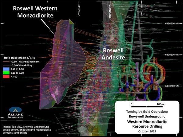
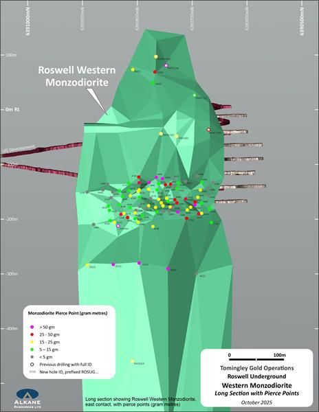
- An intensive underground diamond core drilling program within and extensions to the current Inferred Resource hosted by the Western Monzodiorite domain at Roswell is in progress. Results have been received from 89 holes totalling 18,064 metres that were focussed within the mid-portion of the monzodiorite domain infilling existing drilling to a nominal 15m x 20m grid spacing for the purpose of converting to an Indicated Resource. The drilling confirmed multiple wide, high-grade gold intercepts within the 30m thick monzodiorite. Best intercepts include:
| ROSGT001D incl and | 9.3 metres grading 3.88 g/t Au from 157.9 metres; 1.1 metres grading 10.5 g/t Au from 157.9 metres; 1.8 metres grading 2.05 g/t Au from 177.2 metres. | |
| ROSUG050D | 25.6 metres grading 1.94 g/t Au from 276.1 metres. | |
| ROSUG426D | 24.2 metres grading 2.65 g/t Au from 115.3 metres. | |
| ROSUG430D | 12.1 metres grading 5.44 g/t Au from 115.3 metres. | |
| ROSUG440D incl | 6.5 metres grading 8.03 g/t Au from 166.5 metres; 0.9 metres grading 37.3 g/t Au from 171.6 metres. | |
| ROSUG442D incl | 3.9 metres grading 12.2 g/t Au from 160.1 metres; 1.2 metres grading 25.4 g/t Au from 162 metres. | |
| ROSUG458D and and and | 16 metres grading 1.67 g/t Au from 276.4 metres; 5 metres grading 1.59 g/t Au from 304 metres; 5 metres grading 3.19 g/t Au from 316 metres; 5.1 metres grading 2.82 g/t Au from 328 metres. | |
| ROSUG564D and | 14 metres grading 2.19 g/t Au from 119 metres; 2.8 metres grading 3.94 g/t Au from 140.2 metres. | |
| ROSUG572D incl | 12.4 metres grading 3.00 g/t Au from 109 metres; 0.7 metres grading 30.6 g/t Au from 115.6 metres. | |
| ROSUG584D and inc | 3.2 metres grading 2.04 g/t Au from 128 metres; 7.9 metres grading 14.6 g/t Au from 154 metres; 1.1 metres grading 84.4 g/t Au from 154 metres. | |
| ROSUG595D and and | 3.2 metres grading 1.99 g/t Au from 158.8 metres; 2 metres grading 2.02 g/t Au from 165 metres; 9.5 metres grading 4.73 g/t Au from 170 metres. |
- Additional exploration drilling is planned to test the underground potential at Wyoming Three, extensions to mineralisation north of Caloma and a deep structural target (thrust splay identified by 2D seismic) beneath Roswell. Underground exploration drilling continues at Roswell.
PERTH, Australia, Nov. 02, 2025 (GLOBE NEWSWIRE) -- Alkane Resources Limited (ASX:ALK; TSX:ALK; OTCQX:ALKEF) (‘Alkane’ or ‘the Company’) is pleased to announce the latest results for underground expansion and pre-mine grade control drilling around the existing resources at the Company’s Tomingley Gold Operations (‘Tomingley’) in Central New South Wales.
Alkane Managing Director Nic Earner said: “Most of Tomingley’s deposits are open at depth and along strike. This drilling further demonstrates not only the significant resource expansion potential across the mine site but the potential to discover other deposits.
“Our underground and surface drill programs throughout Tomingley continue. We look forward to continuing to add further resources and mine life.”
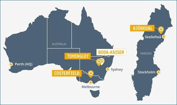
Tomingley
Alkane Resources Ltd 100%
Tomingley is an open pit and underground mining development with a 1Mtpa processing facility in operation since 2014. The development is located near the village of Tomingley, approximately 50 kilometres southwest of Dubbo in Central West New South Wales. Tomingley Gold Operations Pty Ltd is a wholly owned subsidiary of Alkane.
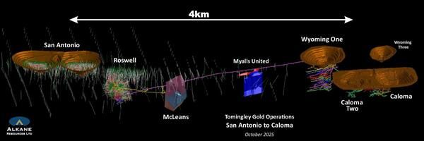
Development at Tomingley has been based on the Wyoming One, Wyoming Three, Caloma, Caloma Two and Roswell gold deposits. To date, mining occurred underground at Wyoming One, Caloma, Caloma Two and Roswell deposits. Roswell stope ore production came on stream in April 2024 (See ASX Announcement dated 22 April 2024 and titled ‘Production Ore Extraction Commences at Roswell’) via an approximately 3 km decline from the Wyoming One open cut.
The Tomingley deposits are located within a tightly folded Ordovician volcano-sedimentary sequence that has been altered to a sericite-carbonate-albite-quartz-pyrite-arsenopyrite assemblage that is typical of orogenic lode-style gold deposits. Mineralised fluids are interpreted to have been focused by differential strain in and around andesitic volcanics due to the rheological competency contrast between the volcanics and the bounding volcaniclastic sediments. The brittle nature of the volcanics often leads to the development of shear-hosted sheeted quartz vein and breccia deposits within and adjacent to the andesitic bodies. Separately, thin carbonaceous mudstone strata appear to have been a focus for shearing and a chemical trap for gold.
Since underground mining commenced in 2018, extensive underground drilling has been employed to define ore reserves for extraction and maintain exploration to define additional resources. The most recent Reserves and Resources were summarised in the ASX Announcement dated 15 October 2025 and titled ‘NSW Resources and Reserves Statements FY25’.
The exploration focus at Tomingley is to define additional underground resources that lie outside the existing Resources and Reserves for the operation.
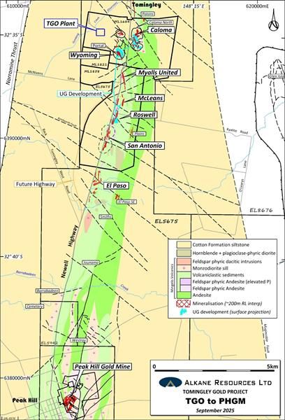
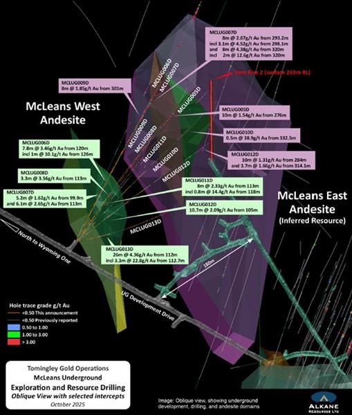
McLeans
The Inferred Resource at McLeans was estimated at 0.87 million tonnes grading 2.51g/t gold for 70,000oz (See ASX Announcement dated 2 May 2022 and titled ‘Roswell Mineral Resource up 37%’). The deposit is primarily hosted by one ‘brittle’ andesite with similar texture and geochemistry as the andesite that is host to most of the mineralisation at the Roswell deposit. The host andesite begins approximately 130m below the surface, is approximately 250m in strike length and remains open at depth. The andesite averages a thickness of 60m but thins to 25m along its upper and northern margins forming a ‘keel’. The mineralisation was interpreted to form three subvertical en échelon sheeted lodes. With high-grade ore shoots focused along the ‘keel’ that remains open at depth along the northern edge of the andesite.
In September, an underground drilling program comprising of 9 holes for a total of 3,247 metres was completed to improve the confidence at the McLeans Inferred Resource by infilling the drilling pattern to 40m x 60m. This drilling has discovered a second ‘western’ andesite with significant gold mineralisation that is located 150 metres west of the current McLeans resource estimation. Significant intercepts hosted by the Western Andesite include:
| MCLUG013D incl | 26 metres grading 4.36g/t Au from 112 metres; 3.3 metres grading 22.8g/t Au from 112.7 metres. | |
| MCLUG012D | 10.7 metres grading 2.09g/t Au from 105 metres. | |
| MCLUG011D incl | 8 metres grading 2.33g/t Au from 113 metres; 0.8 metres grading 14.4g/t Au from 118 metres. | |
| MCLUG007D and | 5.2 metres grading 1.62g/t Au from 99.9 metres; 6.1 metres grading 2.65g/t Au from 113 metres. | |
| MCLUG006D incl | 7.8 metres grading 3.46g/t Au from 120 metres; 1.0 metres grading 10.1g/t Au from 126 metres. |
The nominal drilling pattern was reduced from 80m x 80m that the Inferred Resource was based on to 40m x 60m to help improve the confidence in the estimation at McLeans. Significant intercepts into the Eastern Andesite and the Inferred Resource include:
| MCLUG012D and | 10 metres grading 1.31g/t Au from 284 metres; 3.7 metres grading 1.66g/t Au from 314.1 metres. | |
| MCLUG010D | 0.5 metres grading 38.9g/t Au from 332.5 metres. | |
| MCLUG009D | 8 metres grading 1.85g/t Au from 301 metres. | |
| MCLUG007D incl and incl | 8 metres grading 2.67g/t Au from 293.2 metres; 3.1 metres grading 4.52g/t Au from 298.1 metres; 8 metres grading 4.38g/t Au from 320 metres; 2 metres grading 12.6g/t Au from 320 metres. | |
| MCLUG005D | 10 metres grading 1.54g/t Au from 276 metres. |
Further drilling is planned to test both the Eastern and Western Andesite hosts at McLeans and to include the discovered Western Andesite into the McLeans Resource Estimation.
Roswell
A significant portion of the Roswell underground Inferred Resources (408 kt grading 1.9 g/t Au – see ASX Announcement dated 15 October 2025 and titled ‘NSW Resources and Reserves Statement FY25’) is hosted in the Western Monzodiorite domain. An intensive underground diamond core drilling program targeting the Western Monzodiorite resource and its open extensions is in progress at Roswell. The drilling will improve the confidence of the Mineral Resource Estimation (MRE) and provide a basis for conversion to Ore Reserves.
Results have been received from 89 holes totalling 18,064 metres that are focused within the mid-portion of the monzodiorite domain infilling existing drilling to a nominal 15m x 20m grid spacing for the purpose of converting to an Indicated Resource. The drilling confirmed multiple wide, high-grade gold intercepts within the 30 m thick monzodiorite. The results received are a large part of the current drill program within the Western Monzodiorite and include best intercepts of:
| ROSGT001D incl and | 9.3 metres grading 3.88 g/t Au from 157.9 metres; 1.1 metres grading 10.5 g/t Au from 157.9 metres; 1.8 metres grading 2.05 g/t Au from 177.2 metres. | |
| ROSUG050D | 25.6 metres grading 1.94 g/t Au from 276.1 metres. | |
| ROSUG426D | 24.2 metres grading 2.65 g/t Au from 115.3 metres. | |
| ROSUG430D | 12.1 metres grading 5.44 g/t Au from 115.3 metres. | |
| ROSUG440D incl | 6.5 metres grading 8.03 g/t Au from 166.5 metres; 0.9 metres grading 37.3 g/t Au from 171.6 metres. | |
| ROSUG442D incl | 3.9 metres grading 12.2 g/t Au from 160.1 metres; 1.2 metres grading 25.4 g/t Au from 162 metres. | |
| ROSUG458D and and and | 16 metres grading 1.67 g/t Au from 276.4 metres; 5 metres grading 1.59 g/t Au from 304 metres; 5 metres grading 3.19 g/t Au from 316 metres; 5.1 metres grading 2.82 g/t Au from 328 metres. | |
| ROSUG564D and | 14 metres grading 2.19 g/t Au from 119 metres; 2.8 metres grading 3.94 g/t Au from 140.2 metres. | |
| ROSUG572D incl | 12.4 metres grading 3.00 g/t Au from 109 metres; 0.7 metres grading 30.6 g/t Au from 115.6 metres. | |
| ROSUG584D and incl | 3.2 metres grading 2.04 g/t Au from 128 metres; 7.9 metres grading 14.6 g/t Au from 154 metres; 1.1 metres grading 84.4 g/t Au from 154 metres. | |
| ROSUG595D and and | 3.2 metres grading 1.99 g/t Au from 158.8 metres; 2 metres grading 2.02 g/t Au from 165 metres; 9.5 metres grading 4.73 g/t Au from 170 metres. |
Final results will be published when received and compiled.
Surface exploration drilling on the at Tomingley mine site will commence in November 2025. The diamond core drilling is planned to test the underground potential at Wyoming Three, extensions to mineralisation north of Caloma and to test a deep structural target (thrust splay identified by 2D seismic) beneath Roswell. Underground exploration drilling continues at Roswell.
Tomingley Mineral Resources
| TOMINGLEY GOLD OPERATION MINERAL RESOURCES (as at 30 June 2025) | |||||||||
| MEASURED | INDICATED | INFERRED | TOTAL | Total Gold | |||||
| DEPOSIT | Tonnage | Grade | Tonnage | Grade | Tonnage | Grade | Tonnage | Grade | |
| (kt) | (g/t Au) | (kt) | (g/t Au) | (kt) | (g/t Au) | (kt) | (g/t Au) | (koz) | |
| Open Pittable Resources (cut off 0.40g/t Au) | |||||||||
| San Antonio | 0 | 0.0 | 5,930 | 1.8 | 1,389 | 1.3 | 7,319 | 1.7 | 406 |
| Sub Total | 0 | 0.0 | 5,930 | 1.8 | 1,389 | 1.3 | 7,319 | 1.7 | 406 |
| Underground Resources (cut off 1.3g/t Au) | |||||||||
| Wyoming One | 1033 | 2.7 | 636 | 2.2 | 104 | 2.1 | 1,772 | 2.5 | 140 |
| Wyoming Three | 46 | 2.2 | 24 | 2.0 | 20 | 1.9 | 90 | 2.1 | 6 |
| Caloma One | 598 | 2.2 | 795 | 2.1 | 17 | 1.5 | 1,410 | 2.2 | 98 |
| Caloma Two | 368 | 2.3 | 1499 | 2.3 | 362 | 2.0 | 2,229 | 2.3 | 162 |
| Roswell | 2,649 | 2.9 | 2487 | 2.6 | 408 | 1.9 | 5544 | 2.6 | 476 |
| McLeans | 870 | 2.5 | 870 | 2.5 | 70 | ||||
| Sub Total | 4,694 | 2.7 | 5,441 | 2.4 | 1,781 | 2.2 | 11,915 | 2.5 | 952 |
| TOTAL | 4,694 | 2.7 | 11,371 | 2.1 | 3,170 | 1.8 | 19,234 | 2.2 | 1,358 |
Apparent arithmetic inconsistencies are due to rounding
These Mineral Resources are wholly inclusive of Ore Reserves.
Tomingley Ore Reserves
| TOMINGLEY GOLD OPERATION ORE RESERVES(as at 30 June 2025) | |||||||
| PROVED | PROBABLE | TOTAL | Total Gold | ||||
| DEPOSIT | Tonnage | Grade | Tonnage | Grade | Tonnage | Grade | |
| (Kt) | (g/t Au) | (Kt) | (g/t Au) | (Kt) | (g/t Au) | (Koz) | |
| Open Pittable Reserves (cut off 0.40g/t Au) | |||||||
| San Antonio | 0 | 0.0 | 4,100 | 1.6 | 4,100 | 1.6 | 214 |
| Stockpiles | 314 | 1.1 | 0 | 0 | 314 | 1.1 | 11 |
| Sub Total | 314 | 1.1 | 4,100 | 1.6 | 4,414 | 1.6 | 225 |
| Underground Reserves (cut off 1.3g/t Au and 1.6g/t Au for Roswell) | |||||||
| Wyoming One | 26.4 | 1.8 | 1 | 1.2 | 27 | 1.8 | 2 |
| Caloma One | 134.7 | 1.7 | 337.4 | 1.5 | 472 | 1.6 | 24 |
| Caloma Two | 38.4 | 1.5 | 936.2 | 1.7 | 975 | 1.7 | 53 |
| Roswell | 2,365 | 2.3 | 2,109 | 2.1 | 4,474 | 2.2 | 316 |
| Sub Total | 2,564 | 2.3 | 3,383 | 1.9 | 5,948 | 2.1 | 396 |
| TOTAL | 2,878 | 2.1 | 7,483 | 1.7 | 10,362 | 1.9 | 621 |
Apparent arithmetic inconsistencies are due to rounding
The above tables were published in ASX Announcement dated 15 October 2025 and titled ‘NSW Resources and Reserves Statement FY25’.
| Table 1 – TOMINGLEY GOLD OPERATIONS SIGNIFICANT RESULTS AT MCLEANS - October 2025 (>1.3g/t) | |||||||||||
| Hole ID | Easting (MGA) | Northing (MGA) | RL (m) | Dip | Azimuth (Grid) | Total Depth | Interval From (m) | Interval To (m) | Intercept (m) | Au(g/t) | Ore Zone |
| MCLUG005D | 614060 | 6391501 | -57 | 3 | 82 | 360 | 276 | 286 | 10 | 1.54 | East Andesite |
| incl | 283 | 286 | 3 | 3.12 | |||||||
| MCLUG006D | 614060 | 6391501 | -57 | 1 | 74 | 363 | 120 | 127.8 | 7.8 | 3.46 | West Andesite |
| incl | 126 | 127 | 1 | 10.1 | |||||||
| and | 299 | 300 | 1 | 1.51 | |||||||
| and | 310 | 312 | 2 | 6.11 | East Andesite | ||||||
| incl | 311.3 | 312 | 0.7 | 12.1 | |||||||
| and | 332 | 332.8 | 0.8 | 1.46 | |||||||
| MCLUG007D | 614060 | 6391501 | -58 | -5 | 72 | 357 | 99.9 | 105.1 | 5.2 | 1.62 | |
| and | 113 | 119.1 | 6.1 | 2.65 | West Andesite | ||||||
| incl | 113 | 115.7 | 2.7 | 5.46 | |||||||
| and | 293.2 | 301.2 | 8 | 2.67 | |||||||
| incl | 298.1 | 301.2 | 3.1 | 4.52 | |||||||
| and | 307.8 | 309 | 1.2 | 1.92 | East Andesite | ||||||
| and | 320 | 328 | 8 | 4.38 | |||||||
| incl | 320 | 322 | 2 | 12.6 | |||||||
| MCLUG008D | 614060 | 6391501 | -58 | -7 | 78 | 369.4 | 100 | 101 | 1 | 1.33 | |
| and | 103 | 104.3 | 1.3 | 1.43 | West Andesite | ||||||
| and | 113 | 116.3 | 3.3 | 3.56 | |||||||
| and | 284 | 286.7 | 2.7 | 1.90 | East Andesite | ||||||
| incl | 286 | 286.7 | 0.7 | 5.39 | |||||||
| MCLUG009D | 614060 | 6391501 | -58 | -9 | 70 | 348.4 | 153.5 | 154.1 | 0.6 | 2.49 | West Andesite |
| and | 301 | 309 | 8 | 1.85 | East Andesite | ||||||
| MCLUG010D | 614060 | 6391501 | -58 | -12 | 82 | 357.4 | 106.5 | 107.3 | 0.8 | 1.77 | West Andesite |
| and | 332.5 | 333 | 0.5 | 38.9 | East Andesite | ||||||
| MCLUG011D | 614060 | 6391501 | -58 | -16 | 76 | 350.8 | 113 | 121 | 8 | 2.33 | West Andesite |
| incl | 118 | 118.8 | 0.8 | 14.4 | |||||||
| MCLUG012D | 614060 | 6391501 | -58 | -24 | 81 | 351.6 | 105 | 115.7 | 10.7 | 2.09 | West Andesite |
| incl | 107.7 | 112.7 | 5 | 3.35 | |||||||
| and | 284 | 294 | 10 | 1.31 | |||||||
| incl | 284 | 285 | 1 | 7.01 | |||||||
| and | 314.1 | 317.8 | 3.7 | 1.66 | East Andesite | ||||||
| incl | 316.8 | 317.8 | 1 | 3.95 | |||||||
| and | 320.9 | 321.3 | 0.4 | 1.33 | |||||||
| MCLUG013D | 614060 | 6391501 | -59 | -41 | 81 | 389.7 | 112 | 138 | 26 | 4.36 | |
| incl | 112.7 | 116 | 3.3 | 22.8 | West Andesite | ||||||
| also | 127.2 | 128.8 | 1.6 | 8.59 | |||||||
| and | 373 | 373.6 | 0.6 | 1.91 | East Andesite | ||||||
True widths are approximately 80% of intercept width. Reported intercepts (>1.3g/t Au) are calculated using a broad lower cut of 1.0g/t Au although grades lower than this may be present internally (internal dilution).
| Table 2 - TOMINGLEY GOLD OPERATIONS SIGNIFICANT RESULTS ROSWELL - October 2025 (>1.3g/t) | |||||||||||
| Hole ID | Easting (MGA) | Northing (MGA) | RL (m) | Dip | Azimuth (Grid) | Total Depth | Interval From (m) | Interval To (m) | Intercept (m) | Au(g/t) | Ore Zone |
| ROSGT001D | 613928 | 6390716 | -68 | -49 | 255 | 246.5 | 157.9 | 167.2 | 9.3 | 3.88 | |
| incl | 157.9 | 162 | 4.1 | 6.72 | |||||||
| incl | 157.9 | 159 | 1.1 | 10.5 | Western MZD | ||||||
| also | 165.6 | 166.4 | 0.8 | 7.7 | |||||||
| and | 177.2 | 179 | 1.8 | 2.05 | |||||||
| and | 197 | 197.8 | 0.8 | 1.52 | |||||||
| and | 202.6 | 203.6 | 1 | 1.78 | |||||||
| ROSUG016D | 614070 | 6390825 | -132 | -5 | 274 | 302.9 | No significant intercept (<1.3g/t Au) | ||||
| ROSUG019D | 614070 | 6390826 | -132 | -5 | 287 | 267 | No significant intercept (<1.3g/t Au) | ||||
| ROSUG026D | 614070 | 6390825 | -132 | -5 | 261 | 308.9 | 207.6 | 209.1 | 1.5 | 1.32 | |
| and | 225 | 227 | 2 | 2.25 | |||||||
| and | 229.3 | 232.6 | 3.3 | 3.6 | |||||||
| ROSUG036D | 614070 | 6390825 | -133 | -21 | 261 | 305.8 | 219.2 | 224 | 4.8 | 1.94 | |
| incl | 219.2 | 220.2 | 1 | 6.47 | |||||||
| and | 227.5 | 228 | 0.5 | 5.18 | |||||||
| and | 256 | 262 | 6 | 1.6 | |||||||
| ROSUG037D | 614070 | 6390825 | -133 | -21 | 274 | 290.7 | 215.4 | 217.8 | 2.4 | 2.27 | |
| and | 224 | 224.8 | 0.8 | 3.23 | |||||||
| and | 228.4 | 230 | 1.6 | 3.46 | |||||||
| and | 254.8 | 255.1 | 0.3 | 6.58 | |||||||
| ROSUG038D | 614070 | 6390826 | -133 | -22 | 284 | 287.9 | No significant intercept (<1.3g/t Au) | ||||
| ROSUG050D | 614071 | 6390825 | -133 | -36 | 260 | 356.9 | 267.3 | 268.6 | 1.3 | 1.54 | |
| and | 276.1 | 301.7 | 25.6 | 1.94 | |||||||
| incl | 278 | 281 | 3 | 5.12 | |||||||
| ROSUG051D | 614070 | 6390825 | -133 | -38 | 273 | 356.2 | 264 | 265 | 1 | 6 | |
| and | 300.7 | 301.9 | 1.2 | 47.3 | |||||||
| ROSUG052D | 614071 | 6390826 | -133 | -36 | 285 | 336 | 267.1 | 279 | 11.9 | 1.31 | |
| ROSUG163D | 614053 | 6390740 | -145 | 2 | 264 | 300.2 | 208.6 | 210 | 1.4 | 4.05 | |
| and | 250.3 | 252.1 | 1.8 | 3.18 | |||||||
| ROSUG164D | 614053 | 6390739 | -145 | 3 | 253 | 341.6 | 220.7 | 225.5 | 4.8 | 1.32 | |
| ROSUG171D | 614053 | 6390739 | -145 | -15 | 261 | 332.7 | 215.1 | 216 | 0.9 | 1.68 | |
| and | 224 | 235 | 11 | 2.35 | |||||||
| incl | 224 | 227.1 | 3.1 | 6.53 | Western MZD | ||||||
| and | 243 | 245 | 2 | 1.68 | |||||||
| and | 251 | 255.2 | 4.2 | 2.17 | |||||||
| ROSUG172D | 614053 | 6390739 | -145 | -15 | 251 | 363.3 | 262.6 | 263.6 | 1 | 7.25 | |
| ROSUG409D | 613969 | 6390780 | -143 | 4 | 304 | 150 | 132.7 | 133.3 | 0.6 | 1.6 | |
| ROSUG411D | 613969 | 6390780 | -143 | -8 | 302 | 156.1 | No significant intercept (<1.3g/t Au) | ||||
| ROSUG412D | 613969 | 6390780 | -144 | -19 | 303 | 168.1 | 131.4 | 132.8 | 1.4 | 4.2 | |
| and | 139 | 140.9 | 1.9 | 2.04 | |||||||
| ROSUG413D | 613969 | 6390780 | -143 | -3 | 295 | 149.6 | 122.6 | 124 | 1.4 | 1.79 | |
| and | 130 | 131 | 1 | 5.85 | |||||||
| ROSUG414D | 613969 | 6390780 | -144 | -14 | 295 | 168.1 | 124.9 | 127.8 | 2.9 | 1.81 | |
| ROSUG415D | 613969 | 6390780 | -144 | -23 | 291 | 186 | 122.7 | 123.5 | 0.8 | 1.74 | |
| and | 128 | 135.5 | 7.5 | 2.8 | |||||||
| and | 143.9 | 144.6 | 0.7 | 2.63 | |||||||
| ROSUG417D | 613969 | 6390780 | -142 | 4 | 286 | 150 | 119 | 120 | 1 | 2.32 | |
| and | 121.7 | 122.2 | 0.5 | 3.21 | |||||||
| and | 125 | 126 | 1 | 1.46 | |||||||
| ROSUG418D | 613969 | 6390780 | -143 | -7 | 286 | 152.7 | 115.4 | 116.6 | 1.2 | 1.52 | |
| and | 125 | 130.4 | 5.4 | 2.83 | |||||||
| ROSUG419D | 613966 | 6390772 | -144 | -20 | 284 | 167.7 | 123 | 124 | 1 | 1.72 | |
| and | 141 | 142.2 | 1.2 | 1.32 | |||||||
| ROSUG420D | 613966 | 6390772 | -144 | -27 | 285 | 185.8 | 123.4 | 124.3 | 0.9 | 10.3 | |
| and | 128 | 130.8 | 2.8 | 2.03 | |||||||
| ROSUG421D | 613969 | 6390780 | -142 | 11 | 279 | 146.5 | 106.9 | 109 | 2.1 | 11.3 | |
| incl | 107.3 | 108 | 0.7 | 30.8 | |||||||
| and | 131 | 132 | 1 | 3.18 | |||||||
| ROSUG422D | 613968 | 6390779 | -143 | -3 | 277 | 155.7 | 116.8 | 118 | 1.2 | 1.78 | |
| and | 124.6 | 131.4 | 6.8 | 2.27 | |||||||
| ROSUG423D | 613972 | 6390781 | -170 | -4 | 277 | 152.6 | 109.4 | 109.7 | 0.3 | 2.14 | |
| ROSUG424D | 613966 | 6390772 | -144 | -23 | 277 | 173.7 | 136 | 137.4 | 1.4 | 1.8 | |
| and | 156.7 | 157.8 | 1.1 | 6.61 | |||||||
| ROSUG426D | 613969 | 6390780 | -142 | 4 | 268 | 151.9 | 115.3 | 139.5 | 24.2 | 2.65 | |
| ROSUG427D | 613972 | 6390780 | -169 | 3 | 266 | 153 | 122.9 | 125 | 2.1 | 1.67 | |
| ROSUG428D | 613966 | 6390772 | -144 | -18 | 266 | 161.7 | 112.2 | 122.7 | 10.5 | 2 | |
| incl | 117.9 | 119.8 | 1.9 | 7.31 | |||||||
| ROSUG429D | 613966 | 6390772 | -144 | -28 | 266 | 189 | 156.7 | 164 | 7.3 | 2.07 | |
| incl | 156.7 | 159 | 2.3 | 4.84 | |||||||
| ROSUG430D | 613969 | 6390779 | -142 | 10 | 262 | 161.4 | 118.9 | 131 | 12.1 | 5.44 | |
| incl | 123 | 125 | 2 | 12.2 | |||||||
| also | 129 | 130 | 1 | 14.7 | |||||||
| and | 146 | 147 | 1 | 2.32 | |||||||
| ROSUG431D | 613968 | 6390779 | -143 | -2 | 261 | 164.7 | 113 | 114 | 1 | 2.06 | |
| and | 121 | 122 | 1 | 1.57 | |||||||
| and | 125 | 126 | 1 | 1.47 | |||||||
| and | 131.3 | 136.9 | 5.6 | 1.43 | |||||||
| incl | 134.5 | 136 | 1.5 | 3.12 | |||||||
| ROSUG432D | 613966 | 6390771 | -144 | -13 | 261 | 158.7 | 118 | 128.7 | 10.7 | 1.5 | |
| incl | 128.1 | 128.7 | 0.6 | 8.44 | |||||||
| ROSUG433D | 613966 | 6390771 | -144 | -22 | 258 | 182.7 | 115.9 | 117.1 | 1.2 | 2.67 | |
| ROSUG434D | 613968 | 6390778 | -143 | 3 | 254 | 182.5 | 121.6 | 122.8 | 1.2 | 3.06 | |
| and | 134.5 | 135.5 | 1 | 2.11 | |||||||
| and | 146.2 | 148.2 | 2 | 13.3 | |||||||
| incl | 146.2 | 146.9 | 0.7 | 36 | |||||||
| and | 156.6 | 158.1 | 1.5 | 3.74 | |||||||
| ROSUG435D | 613972 | 6390780 | -169 | 3 | 254 | 179.7 | 135.8 | 144 | 8.2 | 2.77 | Western MZD |
| incl | 139.6 | 140.8 | 1.2 | 13.3 | |||||||
| ROSUG436D | 613966 | 6390771 | -144 | -16 | 251 | 179.8 | 122.7 | 127.9 | 5.2 | 3.06 | |
| ROSUG437D | 613968 | 6390778 | -142 | 7 | 249 | 191.5 | 129.2 | 131.7 | 2.5 | 1.4 | |
| ROSUG438D | 613968 | 6390778 | -143 | -2 | 250 | 191.7 | 156.7 | 157.7 | 1 | 1.94 | |
| ROSUG439D | 613966 | 6390771 | -144 | -12 | 249 | 179.5 | 131.5 | 144 | 12.5 | 2.05 | |
| incl | 139 | 140 | 1 | 6.46 | |||||||
| and | 164.8 | 166 | 1.2 | 1.71 | |||||||
| and | 167.1 | 168.7 | 1.6 | 1.81 | |||||||
| ROSUG440D | 613966 | 6390771 | -144 | -20 | 247 | 197.6 | 129.3 | 130.8 | 1.5 | 2.06 | |
| and | 143.1 | 143.9 | 0.8 | 1.92 | |||||||
| and | 153.6 | 154 | 0.4 | 3.83 | |||||||
| and | 157 | 158.9 | 1.9 | 1.46 | |||||||
| and | 166.5 | 173 | 6.5 | 8.03 | |||||||
| incl | 170.7 | 171.6 | 0.9 | 37.3 | |||||||
| ROSUG441D | 613968 | 6390778 | -143 | 3 | 241 | 194.6 | No significant intercept (<1.3g/t Au) | ||||
| ROSUG442D | 613972 | 6390779 | -170 | 3 | 242 | 209.6 | 160.1 | 164 | 3.9 | 12.2 | |
| incl | 162 | 163.2 | 1.2 | 25.4 | |||||||
| ROSUG443D | 613966 | 6390770 | -144 | -14 | 240 | 196 | 147.9 | 150 | 2.1 | 3.1 | |
| and | 164.2 | 172.4 | 8.2 | 1.32 | |||||||
| incl | 165 | 166 | 1 | 3.03 | |||||||
| ROSUG444D | 613968 | 6390778 | -142 | 9 | 236 | 199.95 | No significant intercept (<1.3g/t Au) | ||||
| ROSUG445D | 613968 | 6390778 | -143 | -2 | 237 | 200.6 | 174.9 | 184.6 | 9.7 | 2.48 | |
| ROSUG446D | 613966 | 6390770 | -144 | -10 | 237 | 191.1 | 161.3 | 167 | 5.7 | 2.17 | |
| incl | 161.3 | 163 | 1.7 | 4.44 | |||||||
| and | 174 | 179 | 5 | 2.37 | |||||||
| ROSUG447D | 613966 | 6390770 | -144 | -18 | 236 | 212.7 | 162.3 | 169.7 | 7.4 | 1.54 | |
| incl | 166.3 | 167.6 | 1.3 | 3.48 | |||||||
| and | 183 | 184.1 | 1.1 | 2.15 | |||||||
| and | 186 | 187 | 1 | 1.43 | |||||||
| and | 190.2 | 191.3 | 1.1 | 2.08 | |||||||
| and | 200 | 201.2 | 1.2 | 5.79 | |||||||
| ROSUG458D | 614085 | 6390770 | -171 | -26 | 261 | 366 | 276.4 | 292.4 | 16 | 1.67 | |
| incl | 288.3 | 292.4 | 4.1 | 4.86 | |||||||
| and | 304 | 309 | 5 | 1.59 | |||||||
| and | 316 | 321 | 5 | 3.19 | |||||||
| and | 328 | 333.1 | 5.1 | 2.82 | |||||||
| ROSUG461D | 614085 | 6390770 | -171 | -26 | 251 | 370.6 | 335.3 | 336 | 0.7 | 1.42 | |
| ROSUG492D | 614082 | 6390761 | -13 | 28 | 285 | 226.9 | 204.8 | 207 | 2.2 | 1.47 | |
| and | 220 | 223 | 3 | 5.45 | |||||||
| incl | 221.1 | 222 | 0.9 | 11.5 | |||||||
| ROSUG496D | 614082 | 6390761 | -14 | 19 | 273 | 231 | 193 | 193.6 | 0.6 | 1.5 | |
| and | 201.7 | 204.7 | 3 | 1.46 | |||||||
| and | 214.8 | 218 | 3.2 | 2.02 | |||||||
| ROSUG499D | 614084 | 6390748 | -14 | 27 | 275 | 240 | 201 | 217 | 16 | 1.63 | |
| ROSUG560D | 613969 | 6390780 | -143 | -2 | 304 | 165 | No significant intercept (<1.3g/t Au) | ||||
| ROSUG561D | 613972 | 6390782 | -170 | -3 | 302 | 140.8 | 126 | 131 | 5 | 1.6 | |
| incl | 126 | 127.1 | 1.1 | 3.78 | |||||||
| and | 135 | 135.9 | 0.9 | 2.21 | |||||||
| ROSUG562D | 613972 | 6390781 | -170 | -15 | 301 | 158.7 | 134.5 | 137.3 | 2.8 | 1.31 | |
| and | 144.6 | 147.9 | 3.3 | 2.07 | |||||||
| ROSUG563D | 613969 | 6390780 | -143 | -8 | 293 | 152.9 | 116 | 116.4 | 0.4 | 2.57 | |
| and | 120.2 | 124 | 3.8 | 1.89 | |||||||
| and | 132.3 | 133.5 | 1.2 | 1.32 | |||||||
| ROSUG564D | 613972 | 6390781 | -170 | -10 | 292 | 152.5 | 119 | 133 | 14 | 2.19 | Western MZD |
| incl | 130.7 | 133 | 2.3 | 5.73 | |||||||
| and | 140.2 | 143 | 2.8 | 3.94 | |||||||
| ROSUG565D | 613966 | 6390772 | -144 | -25 | 293 | 188.8 | 119.4 | 133.2 | 13.8 | 2.3 | |
| incl | 119.4 | 121 | 1.6 | 9.5 | |||||||
| and | 141.6 | 143 | 1.4 | 4.45 | |||||||
| ROSUG567D | 613968 | 6390779 | -143 | -2 | 286 | 146.7 | 120 | 121 | 1 | 1.8 | |
| and | 132 | 134 | 2 | 1.63 | |||||||
| ROSUG568D | 613972 | 6390781 | -170 | -4 | 285 | 149.8 | 113.1 | 120.6 | 7.5 | 1.99 | |
| ROSUG569D | 613966 | 6390772 | -144 | -23 | 286 | 182.7 | 114 | 119 | 5 | 1.39 | |
| and | 123.2 | 124 | 0.8 | 1.81 | |||||||
| and | 126 | 132 | 6 | 1.46 | |||||||
| and | 139.1 | 140.2 | 1.1 | 1.99 | |||||||
| ROSUG572D | 613969 | 6390780 | -142 | 4 | 277 | 146 | 109 | 121.4 | 12.4 | 3 | |
| incl | 115.6 | 116.3 | 0.7 | 30.6 | |||||||
| and | 131.3 | 132 | 0.7 | 3.22 | |||||||
| and | 134.8 | 137.8 | 3 | 1.69 | |||||||
| ROSUG573D | 613969 | 6390779 | -143 | -8 | 277 | 153 | 121.5 | 125.6 | 4.1 | 2.95 | |
| ROSUG574D | 613966 | 6390772 | -144 | -19 | 276 | 161.8 | 111.3 | 112.4 | 1.1 | 1.94 | |
| ROSUG577D | 613968 | 6390779 | -143 | -2 | 269 | 158.8 | 110.5 | 112 | 1.5 | 2.7 | |
| and | 116.8 | 120 | 3.2 | 3.06 | |||||||
| and | 123.7 | 126.6 | 2.9 | 3.51 | |||||||
| ROSUG578D | 613972 | 6390780 | -170 | -3 | 269 | 155.8 | 115 | 120 | 5 | 4.16 | |
| incl | 116.9 | 117.8 | 0.9 | 9.79 | |||||||
| ROSUG579D | 613966 | 6390771 | -144 | -24 | 265 | 177 | 109.7 | 111.1 | 1.4 | 1.91 | |
| and | 115 | 116.1 | 1.1 | 2.03 | |||||||
| and | 118.5 | 120.2 | 1.7 | 2.92 | |||||||
| and | 162.1 | 163.1 | 1 | 3.4 | |||||||
| ROSUG581D | 613969 | 6390779 | -142 | 4 | 260 | 163.6 | 119.7 | 120.7 | 1 | 2.26 | |
| and | 123.3 | 124.6 | 1.3 | 3.26 | |||||||
| and | 129.9 | 130.8 | 0.9 | 1.42 | |||||||
| and | 133.3 | 135.7 | 2.4 | 1.3 | |||||||
| and | 146.7 | 147.5 | 0.8 | 1.43 | |||||||
| ROSUG582D | 613972 | 6390780 | -169 | 3 | 260 | 168 | 120.3 | 121.1 | 0.8 | 1.39 | |
| and | 128.5 | 136 | 7.5 | 2.04 | |||||||
| ROSUG583D | 613966 | 6390771 | -144 | -16 | 260 | 164.8 | 117.9 | 122 | 4.1 | 4.74 | |
| incl | 119.2 | 119.7 | 0.5 | 13.3 | |||||||
| ROSUG584D | 613968 | 6390779 | -142 | 8 | 257 | 181.2 | 120.6 | 122 | 1.4 | 1.56 | |
| and | 128 | 131.2 | 3.2 | 2.04 | |||||||
| and | 143.7 | 145 | 1.3 | 2.36 | |||||||
| and | 154 | 161.9 | 7.9 | 14.6 | |||||||
| incl | 154 | 155.1 | 1.1 | 84.4 | |||||||
| ROSUG585D | 613968 | 6390778 | -143 | -1 | 256 | 179.7 | 117.1 | 118.3 | 1.2 | 2.12 | |
| and | 123.8 | 124.1 | 0.3 | 10.5 | |||||||
| and | 135.2 | 139.1 | 3.9 | 2.48 | |||||||
| and | 144 | 144.5 | 0.5 | 4.95 | |||||||
| ROSUG586D | 613966 | 6390771 | -144 | -12 | 256 | 164.7 | 126.3 | 129.3 | 3 | 1.3 | |
| and | 133 | 134.8 | 1.8 | 1.31 | Western MZD | ||||||
| and | 142 | 143.6 | 1.6 | 1.33 | |||||||
| ROSUG587D | 613966 | 6390771 | -144 | -21 | 254 | 177 | 123.3 | 124.1 | 0.8 | 3.3 | |
| and | 162.3 | 163.4 | 1.1 | 1.37 | |||||||
| ROSUG588D | 613968 | 6390778 | -143 | 3 | 250 | 197.7 | 125 | 127 | 2 | 1.76 | |
| and | 158.8 | 166 | 7.2 | 3.36 | |||||||
| ROSUG589D | 613972 | 6390780 | -169 | 2 | 248 | 194.7 | 139 | 145.1 | 6.1 | 1.83 | |
| and | 149.5 | 154.4 | 4.9 | 3.41 | |||||||
| and | 163.2 | 164.4 | 1.2 | 1.66 | |||||||
| ROSUG590D | 613966 | 6390771 | -144 | -16 | 252 | 182.7 | 127.9 | 128.2 | 0.3 | 1.82 | |
| and | 167.5 | 169 | 1.5 | 1.9 | |||||||
| ROSUG591D | 613968 | 6390778 | -143 | -1 | 245 | 191.6 | 135.2 | 136.1 | 0.9 | 1.64 | |
| and | 172 | 174.2 | 2.2 | 1.61 | |||||||
| ROSUG592D | 613966 | 6390770 | -144 | -10 | 242 | 191.7 | 158.7 | 175.1 | 16.4 | 1.87 | |
| incl | 170 | 175.1 | 5.1 | 4.4 | |||||||
| ROSUG593D | 613966 | 6390771 | -144 | -18 | 242 | 197.8 | 142.2 | 143.8 | 1.6 | 7.3 | |
| and | 160 | 163 | 3 | 2.68 | |||||||
| and | 183 | 184 | 1 | 1.55 | |||||||
| ROSUG594D | 613972 | 6390779 | -170 | 2 | 237 | 200.5 | 173 | 183.6 | 10.6 | 2.11 | |
| ROSUG595D | 613966 | 6390770 | -144 | -13 | 240 | 206.6 | 158.8 | 162 | 3.2 | 1.99 | |
| and | 165 | 167 | 2 | 2.02 | |||||||
| and | 170 | 179.5 | 9.5 | 4.73 | |||||||
| incl | 173 | 176.2 | 3.2 | 8.83 | |||||||
| also | 178.3 | 179.5 | 1.2 | 13.3 | |||||||
| ROSUG638D | 613966 | 6390770 | -143 | 3 | 230 | 192 | No significant intercept (<1.3g/t Au) | ||||
| ROSUG639D | 613966 | 6390770 | -143 | -1 | 232 | 194.6 | 168 | 169.5 | 1.5 | 1.64 | |
| ROSUG641D | 613966 | 6390770 | -143 | -5 | 233 | 200.6 | No significant intercept (<1.3g/t Au) | ||||
| ROSUG642D | 613966 | 6390770 | -144 | -13 | 233 | 200.6 | 176.5 | 181.2 | 4.7 | 5.92 | |
| incl | 178 | 179 | 1 | 10.6 | |||||||
True widths are approximately 80% of intercept width. Reported intercepts (>1.3g/t Au) are calculated using a broad lower cut of 1.0g/t Au although grades lower than this may be present internally (internal dilution).
This document has been authorised for release to the market by Nic Earner, Managing Director.
ABOUT ALKANE ‐ alkres.com ‐ ASX:ALK | TSX: ALK | OTCQX: ALKEF
Alkane Resources (ASX:ALK; TSX:ALK; OTCQX:ALKEF) is an Australia-based gold and antimony producer with a portfolio of three operating mines across Australia and Sweden. The Company has a strong balance sheet and is positioned for further growth.
Alkane’s wholly owned producing assets are the Tomingley open pit and underground gold mine southwest of Dubbo in Central West New South Wales, the Costerfield gold and antimony underground mining operation northeast of Heathcote in Central Victoria, and the Björkdal underground gold mine northwest of Skellefteå in Sweden (approximately 750km north of Stockholm). Ongoing near-mine regional exploration continues to grow resources at all three operations.
Alkane also owns the very large gold-copper porphyry Boda-Kaiser Project in Central West New South Wales and has outlined an economic development pathway in a Scoping Study. The Company has ongoing exploration within the surrounding Northern Molong Porphyry Project and is confident of further enhancing eastern Australia’s reputation as a significant gold, copper and antimony production region.
Competent Person Statement
As an Australian Company with securities listed on the Australian Securities Exchange (ASX), Alkane is subject to Australian disclosure requirements and standards, including the requirements of the Corporations Act 2001 and the ASX. Investors should note that it is a requirement of the ASX Listing Rules that the reporting of ore reserves and mineral resources in Australia is in accordance with the 2012 Edition of the Australasian Code for Reporting of Exploration Results, Mineral Resources and Ore Reserves (the JORC Code) and that Alkane's ore reserve and mineral resource estimates and reporting comply with the JORC Code.
Alkane is also subject to certain Canadian disclosure requirements and standards as a result of its secondary listing on the Toronto Stock Exchange (TSX), including the requirements of National Instrument 43-101 – Standards of Disclosure for Mineral Projects (NI 43-101). Investors should note that it is a requirement of Canadian securities law that the reporting of mineral reserves and mineral resources in Canada and the disclosure of scientific and technical information concerning a mineral project on a property material to Alkane comply with NI 43-101.
Unless otherwise advised above, or in the relevant ASX announcements referenced, the information in this announcement that relates to exploration results, mineral resources and ore reserves is based on information compiled by Mr D I Chalmers, FAusIMM, FAIG (Alkane Technical Advisor) who has sufficient experience that is relevant to the style of mineralisation and type of deposit under consideration and to the activity which he is undertaking to qualify as a Competent Person as defined in JORC Code and as a Qualified Person under NI 43-101. Mr Chalmers consents to the inclusion in this announcement of the matters based on his information in the form and context in which it appears.
The information in this announcement that relates to previously reported exploration results, mineral resources and ore reserves is extracted from the Company’s ASX announcements noted in the text of the announcement and available to view on the Company’s website. The Company confirms that it is not aware of any new information or data that materially affects the information included in the original announcements and that the form and context in which the Competent Person’s findings are presented have not been materially altered.
Technical Reports released to the TSX or for TSX Market
Alkane has prepared the following NI 43-101 compliant technical reports which support the information contained herein, each of which is available under Alkane’s profile on SEDAR+ at www.sedarplus.ca: •
- “Boda-Kaiser Copper-Gold Project, New South Wales, Australia” with an effective date of June 6, 2025; and
- “Tomingley and Peak Hill Gold Projects, NSW, Australia” with an effective date of June 6, 2025.
Reference should be made to the full text of the foregoing technical reports for the assumptions, qualifications and limitations relating to the Mineral Resource Estimates and Ore Reserves contained therein and herein. All material assumptions and technical parameters underpinning the estimates in the technical reports continue to apply and have not materially changed.
Cautionary Note Regarding Forward-Looking Information and Statements
This announcement contains certain forward-looking information and forward-looking statements within the meaning of applicable securities legislation and may include future-oriented financial information or financial outlook information (collectively Forward-Looking Information). Actual results and outcomes may vary materially from the amounts set out in any Forward-Looking Information. As well, Forward-Looking Information may relate to: future outlook and anticipated events; expectations regarding exploration potential; production capabilities and future financial or operating performance, including AISC, investment returns, margins and share price performance; production and cost guidance and the timing thereof; issuing updated resources and reserves estimate and the timing thereof; the potential of Alkane to meet industry targets, public profile and expectations; and future plans, projections, objectives, estimates and forecasts and the timing related thereto.
Forward-Looking Information is generally identified by the use of words like "will", "create", "enhance", "improve", "potential", "expect", "upside", "growth" and similar expressions and phrases or statements that certain actions, events or results "may", "could", or "should", or the negative connotation of such terms, are intended to identify Forward-Looking Information.
Although Alkane believes that the expectations reflected in the Forward-Looking Information are reasonable, undue reliance should not be placed on Forward-Looking Information since no assurance can be provided that such expectations will prove to be correct. Forward-Looking Information is based on information available at the time those statements are made and/or good faith belief of the officers and directors of Alkane as of that time with respect to future events and are subject to risks and uncertainties that could cause actual results to differ materially from those expressed in or suggested by the Forward-Looking Information. Forward-Looking Information involves numerous risks and uncertainties. Such factors include, without limitation: risks relating to changes in the gold and antimony price.
Forward-Looking Information is designed to help readers understand Alkane’s views as of that time with respect to future events and speak only as of the date they are made. Except as required by applicable law, Alkane assumes no obligation to update or to publicly announce the results of any change to any forward-looking statement contained or incorporated by reference herein to reflect actual results, future events or developments, changes in assumptions or changes in other factors affecting the Forward-looking Information. If Alkane updates any one or more forward-looking statements, no inference should be drawn that the company will make additional updates with respect to those or other Forward-looking Information. All Forward-Looking Information contained in this announcement is expressly qualified in its entirety by this cautionary statement.
Disclaimer
Alkane has prepared this announcement based on information available to it. No representation or warranty, express or implied, is made as to the fairness, accuracy, completeness or correctness of the information, opinions or conclusions contained in this announcement. To the maximum extent permitted by law, none of Alkane, its directors, officers, employees, associates, advisers and agents, nor any other person accepts any liability, including, without limitation, any liability arising from fault or negligence on the part of any of them or any other person, for any loss arising from the use of this announcement or its contents or otherwise arising in connection with it.
This announcement is not an offer, invitation, solicitation, or other recommendation with respect to the subscription for, purchase or sale of any security, and neither this announcement nor anything in it shall form the basis of any contract or commitment whatsoever.
APPENDIX 1
JORC Code, 2012 Edition – Table 1 report – Roswell and McLeans October 2025
Section 1 Sampling Techniques and Data
(Criteria in this section apply to all succeeding sections.)
| Criteria | JORC Code explanation | Commentary |
| Sampling techniques |
| Resource infill and extension drilling has been undertaken at the McLeans and Roswell Western MZD Inferred Resources as part of mine development underground drilling. This drilling was NQ2 core at Roswell and HQ2 at McLeans. DD sample intervals were defined by site geologists during logging to honour geological boundaries with whole core sampled on intervals defined by the geologist. |
| Core was laid out in suitably labelled core trays. A core marker (core block) was placed at the end of each drilled run and labelled with the hole number, down hole depth, length of drill run. Core was aligned and measured by tape, comparing back to this down hole depth consistent with industry standards. | |
| Diamond core sample intervals were defined by geologists during logging to honour geological boundaries and cut in half with a saw if HQ2 (at McLeans). NQ2 diamond core drilling conducted at Roswell was whole core sampled. All samples sent to the laboratory were crushed and/or pulverised to produce a ~100g pulp for assay process. All samples are fire assayed using a 50g charge. | |
| Drilling techniques |
| Diamond core holes at Roswell were drilled NQ2 and at McLeans were drilled HQ2. |
| Drill sample recovery |
| DD - core loss was identified by drillers and calculated by geologists when logging. Generally ≥99% was recovered. |
| All NQ2 core was whole sampled to ensure representativity of sampling. Larger diameter HQ2 was half sampled. | |
| There is no known relationship between sample recovery and grade. | |
| Logging |
| DD - all core was laid out in core trays and geologically logged for characteristics such as lithology, weathering, alteration (type, character and intensity), veining (type, character and intensity) and mineralisation (type, character and volume percentage). A brief geotechnical log was also undertaken collecting parameters such as core recovery, RQD, fracture count, and fracture type and orientation. |
| All logging was qualitative with visual estimates of the various characteristics. . DD - Core was photographed and any unsampled core is retained for reference purposes. | |
| All DD core samples have been geologically and geotechnically logged by qualified geologists. | |
| Sub-sampling techniques and sample preparation |
| HQ2 core sawn with half core samples submitted for analysis. NQ2 core whole sampled and submitted for analysis. |
| Not applicable – no ‘non core’ sub sampling techniques or sample preparation used. | |
| Samples were delivered to ALS Minerals Laboratory, Orange NSW. Crushed with 70% <2mm (ALS code CRU-31), split by riffle splitter (ALS code SPL-21), and pulverised 1000grm to 85% <75um (ALS code PUL-32). Crushers and pulverisers are washed with QAQC tests undertaken (ALS codes CRU-QC, PUL-QC). | |
| Internal QAQC system in place to determine accuracy and precision of assays. | |
| Entire core sampling was undertaken for NQ2. Non-biased core cutting for HQ2 using an orientation line marked on the core. | |
| Sample sizes are industry standard and considered appropriate. | |
| Quality of assay data and laboratory tests |
| Gold was determined using a 50g charge fused at approximately 1100°C with alkaline fluxes, including lead oxide. The resultant prill was dissolved in aqua regia and gold determined by flame AAS |
| Not applicable to this report or deposit as no geophysical tools, spectrometers, handheld XRF instruments were used. | |
| Commercially prepared Certified Reference Materials (CRM) and blanks were inserted at 1 in 50 samples. CRM’s were not identifiable to the laboratory. Laboratory QAQC sampling includes insertion of CRM samples, internal duplicates and screen tests. This data was reported for each sample submission. | |
| Verification of sampling and assaying |
| Drill data was compiled and collated and reviewed by senior staff. External consultants do not routinely verify data until resource estimation procedures are deemed necessary |
| Twinned holes have not been used for this drilling. | |
| All drilling data at Tomingley is stored in a “Datashed” Microsoft SQL database. All primary assay data was received from the laboratory as electronic data files which were imported into sampling database with verification procedures in place. QAQC analysis was undertaken for each laboratory report. Digital copies of Certificates of Analysis (COA) are stored in a central database with regular (daily) backup. Original survey data is stored on site. Data was also verified on import into mining related software. | |
| No assay data was adjusted. | |
| Location of data points |
| Drill holes were laid out by underground survey. DD holes were surveyed during drilling to maintain drilling direction and then at 6m intervals on retrieval of rod string using a multi shot electronic camera. |
| Drill holes laid out in MGA. | |
| The area is very flat. A site based digital terrain model was developed from accurate (± 0.1m) survey control by licenced surveyors. | |
| Data spacing and distribution |
| Infill drilling at the Roswell Western MZD is completed on a pattern of 10m x 15m pattern when combined with exploration drill holes. Infill resource drilling at McLeans was completed on nominal 20m x 20m spacing when combined with previous exploration drill holes. The drill hole spacing is similar to that used at the other Tomingley deposits and has been determined as sufficient. |
| The mineralisation domains tested by this drilling is classified as Inferred based on its data distribution and hosted in the same monzodiorite or andesite domain. All the new drilling intersected the monzodiorite or andesite host and their spacing and distribution will be sufficient to further inform this Inferred resource mineralisation domain. | |
| Samples are diamond core and intervals are based on geological logging, and are simple intervals as described earlier in the table. | |
| Orientation of data in relation to geological structure |
| Much care was given to attempt to intersect mineralisation at an optimal angle but location of drill drives is the major determination of intersection angle. Most holes are 80% of true thickness. |
| It is not thought that drilling direction will bias assay data. | |
| Sample security |
| All samples were bagged in tied numbered calico bags, grouped into larger tied polyweave bags and transported to the laboratory in Orange by courier. Sample submission sheets were delivered with the samples and also emailed to the laboratory. All sample submissions were documented via ALS tracking system and all assays were reported via email. Sample pulps were returned to site and were stored for an appropriate length of time (minimum 3 years). The Company has in place protocols to ensure data security. |
| Audits or reviews |
| The Company does not routinely have external consultants verify exploration data until resource estimation procedures are deemed necessary. |
Section 2 Reporting of Exploration Results
(Criteria listed in the preceding section also apply to this section.)
| Criteria | JORC Code explanation | Commentary |
| Mineral tenement and land tenure status |
| The three Tomingley mining licences are held in the name of Tomingley Gold Operations Pty Ltd (TGO), a wholly owned subsidiary of Alkane Resources Ltd. The Roswell and McLeans deposits are within ML 1858. |
| ML1684 and ML 1821 expire on 11 February 2034. ML 1858 expires on 19 July 2044. | |
| Exploration done by other parties |
| All reported drilling has been completed by TGO. |
| Geology |
| Geological nature of the Tomingley Deposits is well documented elsewhere. Mineralisation is associated with quartz veining and alteration focused within sub-volcanic basaltic-andesite sills and adjacent volcaniclastic sediments. The deposits appear to have formed as the result of a rheological contrast between the porphyritic sub-volcanic sills and the surrounding volcaniclastic sediments, with the sills showing brittle fracture and the sediments ductile deformation and have many similarities to well documented orogenic - lode-style gold deposits. Geological nature of the Tomingley Deposits is well documented elsewhere. |
| Drill hole Information |
| See body of announcement. |
| All drill holes (detailing significant assay results of >1.3g/t Au) are reported. Exclusion of assay data from below this cut-off will not detract from the understanding of this report. All drill data has been previously reported. | |
| Data aggregation methods |
| Reported results have been –
|
| Exploration results are reported as length weighted average grades with internal high-grade intercepts reported separately. | |
| No metal equivalents are reported. | |
| Relationship between mineralisation widths and intercept lengths |
| Reported results include the drilled width and an estimate of true width. At Roswell and McLeans the true width is approximately 80% of the drilled width. |
| Diagrams |
| Cross sections and plans showing drilling with 3D geological modelling are included in the body of this announcement. |
| Balanced reporting |
| Comprehensive reporting has been undertaken with all drill holes listed in the included table. |
| Other substantive exploration data |
| No other exploration data is considered meaningful for reporting. |
| Further work |
| See body of announcement. Further underground drilling will be undertaken to improve resource classification from Inferred to Indicated at Roswell and McLeans. Further drilling will delineate a resource for the recently discovered western andesite at McLeans. |
| See figures included in the announcement. |
CONTACT: NIC EARNER, MANAGING DIRECTOR & CEO, ALKANE RESOURCES LTD, TEL +61 8 9227 5677
INVESTORS & MEDIA: NATALIE CHAPMAN, CORPORATE COMMUNICATIONS MANAGER, TEL +61 418 642 556
Subscribe to releases from Globenewswire
Subscribe to all the latest releases from Globenewswire by registering your e-mail address below. You can unsubscribe at any time.
Latest releases from Globenewswire
Oma Säästöpankki Oyj3.11.2025 08:30:00 CET | Press release
Oma Savings Bank Plc’s Interim Report January-September 2025: Moderate result in challenging operating environment – solvency strengthened further
Jyske Bank3.11.2025 08:19:43 CET | Press release
Share repurchase programme: Transactions of week 44 2025
Jyske Bank3.11.2025 08:19:43 CET | Pressemeddelelse
Aktietilbagekøb: Transaktioner i uge 44 2025
Aspo Plc3.11.2025 08:15:00 CET | Press release
Aspo to start repurchasing own shares for its share-based incentive plans
Aspo Plc3.11.2025 08:05:00 CET | Press release
Inside information: Aspo provides update on its strategic progress: alternatives include partial demerger or divestment of ESL Shipping
In our pressroom you can read all our latest releases, find our press contacts, images, documents and other relevant information about us.
Visit our pressroom